 Filter: Categories of Wisconsin Historical Images
Filter: FORMAT_TYPE of prints, photomechanical
Filter: Year of 1800-1899
Filter: Categories of Wisconsin Historical Images
Filter: FORMAT_TYPE of prints, photomechanical
Filter: Year of 1800-1899
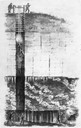
| Date: | 1844 |
|---|---|
| Description: | Cross section drawing of a Wisconsin lead mine. |
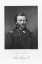
| Date: | 1865 |
|---|---|
| Description: | An engraving from a daguerreotype of Ulysses S. Grant. |
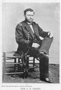
| Date: | 1861 |
|---|---|
| Description: | Civil War portrait of Ulysses S. Grant seated wearing a military uniform. |

| Date: | 1876 |
|---|---|
| Description: | Bird's-eye view of Black Earth. |

| Date: | 1867 |
|---|---|
| Description: | Birds-eye drawing of Appleton, Outagamie Co., depicting street names and street layout, houses, the Fox River, the court house, jail, school houses, Lawren... |

| Date: | 1836 |
|---|---|
| Description: | Map of all Dane County and eastern towns. |

| Date: | 1839 |
|---|---|
| Description: | This map shows the hydrology of Madison and its vicinity at the height of interest in a proposed Milwaukee and Rock River Canal. It was made by Thomas Jeff... |

| Date: | 1839 |
|---|---|
| Description: | A map of the Wiskonsin [sic] and Neenah or Fox Rivers. |
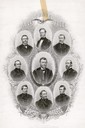
| Date: | 1867 |
|---|---|
| Description: | Engraving of portraits of Generals in the Union Army during the Civil War. U.S. Grant is in the center, with H.W. Halleck on his left, and clockwise from t... |
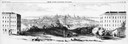
| Date: | 1858 |
|---|---|
| Description: | Panoramic sketch of State Street between North and South Halls on the University of Wisconsin-Madison campus. Published in Frank Leslie's Illustrate Newsp... |

| Date: | 1880 |
|---|---|
| Description: | Alma was platted and settled in 1855, on a narrow strip of land between high bluffs and the Mississippi River. Its location made it a popular shipping cent... |

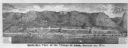
| Date: | 1885 |
|---|---|
| Description: | Mining and lumbering provided the impetus for the development of northern Wisconsin and Ashland was ideally situated to become a leading city of the "new W... |

| Date: | 1870 |
|---|---|
| Description: | Baraboo was first settled around 1838, and by 1870 it had become the county seat and the thriving village illustrated here. This birds eye drawing depicts ... |

| Date: | 1876 |
|---|---|
| Description: | Bird's-eye view of Middleton with an inset of a school house. |
| Date: | 1877 |
|---|---|
| Description: | Bird's-eye panorama of Alma, from "An Illustrated Historical Atlas of Buffalo and Pepin Counties." |

| Date: | 07 17 1857 |
|---|---|
| Description: | A stock certificate of the Watertown and Madison Railroad Company, one share #85, issued to Darwin Clark for the sum of $50.00. This was signed by the rail... |
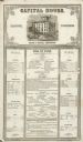
| Date: | 12 02 1855 |
|---|---|
| Description: | The Capital House bill of fare for Sunday, December 2, 1855. Proprietors were Nelson & Russell. |

| Date: | 1869 |
|---|---|
| Description: | Birds-eye drawing of Boscobel, Grant County, depicts street names and street layouts, houses, rivers and trees. A reference key at the bottom of the map sh... |

| Date: | 1886 |
|---|---|
| Description: | Bird's-eye map of Chippewa Falls, county seat of Chippewa Falls. |

| Date: | 1884 |
|---|---|
| Description: | Bird's-eye map of Delavan with inset of the State Institute for Deaf and Dumb. |
If you didn't find the material you searched for, our Library Reference Staff can help.
Call our reference desk at 608-264-6535 or email us at: