 Filter: Categories of Wisconsin Historical Images
Filter: FORMAT_TYPE of prints, photomechanical
Filter: Subject of water
Filter: County of Sauk
Filter: Categories of Wisconsin Historical Images
Filter: FORMAT_TYPE of prints, photomechanical
Filter: Subject of water
Filter: County of Sauk

| Date: | 1870 |
|---|---|
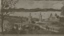
| Description: | Baraboo was first settled around 1838, and by 1870 it had become the county seat and the thriving village illustrated here. This birds eye drawing depicts ... |

| Date: | 1870 |
|---|---|
| Description: | Bird's-eye map of Prairie du Sac. |

| Date: | 1870 |
|---|---|
| Description: | Sauk City is the oldest incorporated village in Wisconsin (incorporated in 1854) and also has the oldest organized volunteer fire department in the state, ... |

| Date: | 1883 |
|---|---|
| Description: | Bird's-eye map of Prairie du Sac, Wisconsin with an inset of Clifton. |

| Date: | 1883 |
|---|---|
| Description: | Bird's-eye map of Sauk City. |
| Date: | |
|---|---|
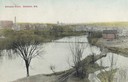
| Description: | Elevated view of the Baraboo River towards a bridge, water tower, and the town beyond. Caption reads: "Baraboo River, Baraboo, Wis." |
| Date: | 1914 |
|---|---|
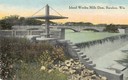
| Description: | Slightly elevated view of the dam, with a bridge in the background. Caption reads: "Island Wollen Mills Dam, Baraboo, Wis." |

| Date: | 1950 |
|---|---|
| Description: | Map showing buildings formerly used as Ringling Brothers Circus winter quarters, along with adjoining buildings. |
| Date: | 1910 |
|---|---|
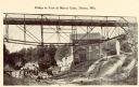
| Description: | Photographic postcard of the bridge near a mill. Caption reads: "Bridge at Foot of Mirror Lake, Delton, Wis." |
| Date: | 1922 |
|---|---|
| Description: | View of the approach to the Wisconsin River bridge. |
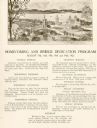
| Date: | 1922 |
|---|---|
| Description: | Homecoming and bridge dedication program, featuring an image of the approach to the Wisconsin River Bridge, and a listing of the celebration's planned even... |
| Date: | 1910 |
|---|---|
| Description: | View from below along the left side of the Wisconsin River bridge. Tree-covered hills are on the opposite shoreline. Caption reads: "Wisconsin River Bridge... |

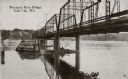
| Date: | 1910 |
|---|---|
| Description: | This was the first bridge built across the Wisconsin River, constructed about 1850, although it was not opened to traffic until 1852. It was torn down in 1... |

| Date: | |
|---|---|
| Description: | Map of Baraboo and its surroundings, showing the ancient mound city, the water power, and thoroughfares, drawn by William H. Canfield. Canfield includes sk... |
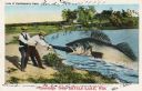
| Date: | 07 28 1933 |
|---|---|
| Description: | Colorized postcard in the Tall-Tale style. Two men standing on the shore are pulling a third man's leg out of a enormous fish's mouth. Two automobiles and ... |
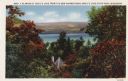
| Date: | 1933 |
|---|---|
| Description: | Colorized postcard of Devil's Lake and bluffs seen through the trees. Some of the trees have autumn color. A roof and chimney are visible. The text at the ... |
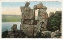
| Date: | |
|---|---|
| Description: | Colorized postcard of the rock formation called the Devil's Doorway in Devil's Lake State Park. Trees can be seen to the right and below. The lake, bluffs ... |
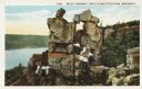
| Date: | |
|---|---|
| Description: | Colorized postcard of the rock formation called the Devil's Doorway in Devil's Lake State Park. Trees can be seen to the right and below. The lake, bluffs ... |

| Date: | 1914 |
|---|---|
| Description: | Colorized postcard of the rock formation called the Devil's Doorway in Devil's Lake State Park. Trees can be seen below. The lake, bluffs, roads and buildi... |
If you didn't find the material you searched for, our Library Reference Staff can help.
Call our reference desk at 608-264-6535 or email us at:
