Filter: Categories of Wisconsin Historical Images
Filter: FORMAT_TYPE of prints, photomechanical
Filter: Subject of transportation
Filter: County of Grant
Filter: Categories of Wisconsin Historical Images
Filter: FORMAT_TYPE of prints, photomechanical
Filter: Subject of transportation
Filter: County of Grant

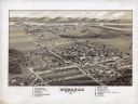
| Date: | 1869 |
|---|---|
| Description: | Birds-eye drawing of Boscobel, Grant County, depicts street names and street layouts, houses, rivers and trees. A reference key at the bottom of the map sh... |

| Date: | 1875 |
|---|---|
| Description: | Bird's-eye map of Platteville. |

| Date: | 1829 |
|---|---|
| Description: | Drawing of Cassville depicting a horse cart on the river's edge, with men and boats. |
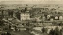
| Date: | |
|---|---|
| Description: | An engraving based on a drawing by Alexander Simplot of the Platteville Brewery (spelled Plattville). It is an elevated perspective showing the main buildi... |
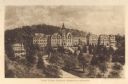
| Date: | 1910 |
|---|---|
| Description: | Elevated view of Saint Clara Academy, formerly known as Saint Clara College. Caption reads: "Saint Clara College — Sinsinawa, Wisconsin". |

| Date: | |
|---|---|
| Description: | Plan of township no. 3 north, range no. 5 west of the 4th principal meridian. |
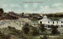
| Date: | 1915 |
|---|---|
| Description: | Elevated view of mining operations. Caption reads: "'A Busy Corner' of Platteville." |
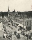
| Date: | 1907 |
|---|---|
| Description: | Elevated view of Main Street. Crowds line the sidewalks, and horse drawn vehicles and people are moving down the street. |

| Date: | 1911 |
|---|---|
| Description: | Caption reads: "Main Street, looking East, Platteville,,[sic] Wis." |
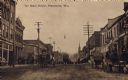
| Date: | 1905 |
|---|---|
| Description: | View looking down center of Main Street, with horse-drawn vehicles. Caption reads: "On Main Street, Platteville, Wis." |

| Date: | 1912 |
|---|---|
| Description: | Sanborn insurance map of the main street in Potosi, Wisconsin, with an inset for the Potosi Brewery. |
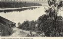
| Date: | |
|---|---|
| Description: | Black and white postcard of an elevated view of the Old Covered Bridge crossing the Wisconsin River. The bridge is on the left and the river is on the righ... |
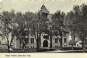
| Date: | |
|---|---|
| Description: | Photographic postcard of Boscobel High School seen through the trees. Text below reads: "High School, Boscobel, Wis." |

| Date: | 1835 |
|---|---|
| Description: | Plat for a proposed Sinsinawa City (never built), in Grant County, Wis. When it became clear in the mid-1830s that Wisconsin Territory would be established... |

| Date: | |
|---|---|
| Description: | A map of Grant County, Wisconsin that shows the townships, cities, villages, rivers and streams, roads and railroads, landownership, post offices. The map... |

| Date: | |
|---|---|
| Description: | A map of Grant County, Wisconsin showing the locations of townships, towns, cities, villages, roads, railroads, schools, cemeteries, churches, rivers, and ... |

| Date: | 1920 |
|---|---|
| Description: | A map of the Nelson-Dewey State Park at the confluence of the Mississippi and Wisconsin rivers, showing the topographical features of the area, as well as ... |

| Date: | 1920 |
|---|---|
| Description: | This 1920 map actually depicts present-day Wyalusing State Park at the confluence of the Mississippi and Wisconsin rivers in the Town of Wyalusing, Grant C... |

| Date: | 1842 |
|---|---|
| Description: | Relief shown by hachures. Shows furnaces, saw mills, houses, roads, grist mills, entries, reservations, and diggings. "Compiled by order of the Board of C... |
If you didn't find the material you searched for, our Library Reference Staff can help.
Call our reference desk at 608-264-6535 or email us at: