Filter: Categories of Wisconsin Historical Images
Filter: FORMAT_TYPE of prints, photomechanical
Filter: Subject of transportation
Filter: County of Dane
Filter: Categories of Wisconsin Historical Images
Filter: FORMAT_TYPE of prints, photomechanical
Filter: Subject of transportation
Filter: County of Dane

| Date: | 1855 |
|---|---|
| Description: | Bird's-eye view of Madison. "Taken from the Water Cure, South Side of Lake Monona, 1855." |

| Date: | 1908 |
|---|---|
| Description: | Colored map showing a panoramic view of Madison in great detail. The Wisconsin State Capitol is located at the center, with Lake Mendota in the background ... |
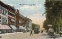
| Date: | 1900 |
|---|---|
| Description: | View down Main Street on the Capitol Square. Caption reads: "Main Street, looking West." |

| Date: | 1884 |
|---|---|
| Description: | A sign for Fauerbach's Brewery depicting a young woman and the brewery. |
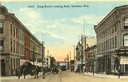
| Date: | 1910 |
|---|---|
| Description: | Colorized view of King Street, looking east, with a streetcar. Lake Monona is in the background. Caption reads: "King Street, looking East, Madison, Wis." |

| Date: | 1873 |
|---|---|
| Description: | Map of the township of Windsor, from the "Atlas of Dane County." |

| Date: | 03 1892 |
|---|---|
| Description: | Detail map including West Washington Avenue, West Main Street, West Wilson Street, and North and South Bedford Streets. Includes the Chicago, Milwaukee & S... |

| Date: | 1876 |
|---|---|
| Description: | Bird's-eye view of Black Earth. |

| Date: | 1910 |
|---|---|
| Description: | Map of Dane County rural delivery in Madison and the town of Westport. |

| Date: | 1916 |
|---|---|
| Description: | Map of all automobile roads out of Madison, compliments of the Madison Board Of Commerce. |

| Date: | 1910 |
|---|---|
| Description: | Map of the general plan of the district of the Four Lakes. |
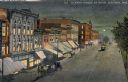
| Date: | 1910 |
|---|---|
| Description: | Elevated view at night of streetcars moving along the Capitol Square on Pinckney Street. Walzinger's Drugstore is one of the prominent storefronts on the l... |

| Date: | |
|---|---|
| Description: | View from a stone bridge towards Vilas Park, with children riding the carousel (merry-go-round) and a kiddie train adjacent to the lagoon. |
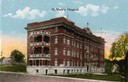
| Date: | 1915 |
|---|---|
| Description: | St. Mary's Hospital soon after its completion in 1911. Caption reads: "St. Mary's Hospital." |
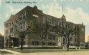
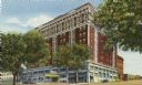
| Date: | 1915 |
|---|---|
| Description: | Central High School, designed by St. Paul architect Cass Gilbert and partially razed in 1986. Caption reads: "High School, Madison, Wis." |

| Date: | 1876 |
|---|---|
| Description: | Bird's-eye view of Middleton with an inset of a school house. |

| Date: | 07 17 1857 |
|---|---|
| Description: | A stock certificate of the Watertown and Madison Railroad Company, one share #85, issued to Darwin Clark for the sum of $50.00. This was signed by the rail... |

| Date: | 1867 |
|---|---|
| Description: | Bird's-eye map of Madison with insets of the University, Rasdall House, Vilas House, and the Wisconsin State Capitol. View includes cattail marsh, smokesta... |
If you didn't find the material you searched for, our Library Reference Staff can help.
Call our reference desk at 608-264-6535 or email us at: