 Filter: Categories of Wisconsin Historical Images
Filter: FORMAT_TYPE of prints, photomechanical
Filter: Subject of forests and forestry
Filter: Categories of Wisconsin Historical Images
Filter: FORMAT_TYPE of prints, photomechanical
Filter: Subject of forests and forestry

| Date: | 1883 |
|---|---|
| Description: | Bird's-eye map of Sauk City. |
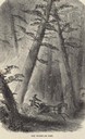
| Date: | |
|---|---|
| Description: | Illustration of a man driving a horse-drawn wagon out of burning woodland. |
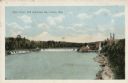
| Date: | |
|---|---|
| Description: | View of the mill and the dam, and the river. The area around the mill is heavily forested. Caption reads: "Dells Paper Mill and Dam, Eau Claire, Wis." |
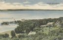
| Date: | 1945 |
|---|---|
| Description: | Elevated view of American Baptist Assembly Grounds from Judson Tower. Below near the tree-covered shoreline are buildings, a recreation area, and a harbor ... |

| Date: | 1910 |
|---|---|
| Description: | Aerial view of some of the 26 lakes known collectively as the Chain O' Lakes. Caption reads: "Aeroplane View of Chain O'Lakes, Waupaca, Wis." |

| Date: | 1910 |
|---|---|
| Description: | Elevated view of North Branch Street. Caption reads: "North Branch Street, Wabeno, Wis." |
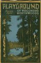
| Date: | 1931 |
|---|---|
| Description: | Cover of a Wisconsin tourism pamphlet for the 1932 season. |
| Date: | 1910 |
|---|---|
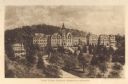
| Description: | Elevated view of Saint Clara Academy, formerly known as Saint Clara College. Caption reads: "Saint Clara College — Sinsinawa, Wisconsin". |

| Date: | 1939 |
|---|---|
| Description: | A color, pictorial map. Scale: 10 miles to the inch. Shows state parks and forests, proposed state parkways, proposed state monuments and memorials, nation... |
| Date: | 1936 |
|---|---|
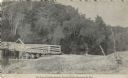
| Description: | Exterior view of a logging camp on the Menominee Indian Reservation. The three buildings are surrounded by forest. |
| Date: | 1946 |
|---|---|
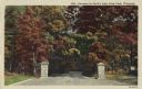
| Description: | Colorized postcard of the entrance to Devil's Lake State Park. Trees and foliage fill the scene and it appears to be autumn. Stone pillars are on either si... |
| Date: | 1913 |
|---|---|
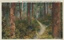
| Description: | Colorized postcard of a hiking trail winding through the forest. Some trees are showing autumn color. Caption reads: "Brule River State Park, Wisconsin. Al... |
| Date: | 1913 |
|---|---|
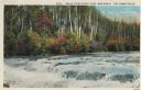
| Description: | Colorized postcard view of the Lower Falls on the Brule River flowing through the forest. Some trees are showing autumn color. Caption reads: "Brule River ... |
| Date: | 1926 |
|---|---|
| Description: | Black and white postcard view of Cedar Island Lodge, located on the Brule River, owned by Henry Clay Pierce, businessman and financier. It was dubbed the S... |
| Date: | |
|---|---|
| Description: | Black and white postcard view of the wooden Ford Bridge. Trees on a hill are on the far shoreline. Caption reads: "The Ford Bridge Across Willow River, Bur... |
| Date: | |
|---|---|
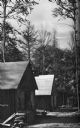
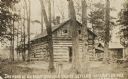
| Description: | Two-story log cabin and shed in a forest. The building was used by early settlers in Langlade County near Antigo. Caption reads: "The Home of an Early Land... |

| Date: | |
|---|---|
| Description: | Color view from hill toward a lone boater on Kennedy Lake. Caption reads: "Kennedy Lake, Antigo, Wis." |
| Date: | |
|---|---|
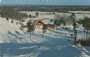
| Description: | Color postcard of an elevated view of the Chalet at Mt. Telemark and surrounding area, and many skiers and several ski lifts. |

| Date: | |
|---|---|
| Description: | Color postcard of a view of a lake from a shoreline. A power boat and a fishing boat can be seen through the trees. "Cable, Wisc." is printed in red on the... |
| Date: | |
|---|---|
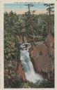
| Description: | View of water streaming down the rock and tree-lined Tyler Falls. A white walk bridge is in the background. |
If you didn't find the material you searched for, our Library Reference Staff can help.
Call our reference desk at 608-264-6535 or email us at: