 Filter: Categories of Wisconsin Historical Images
Filter: FORMAT_TYPE of prints, photomechanical
Filter: Subject of economics
Filter: County of Columbia
Filter: Categories of Wisconsin Historical Images
Filter: FORMAT_TYPE of prints, photomechanical
Filter: Subject of economics
Filter: County of Columbia
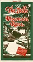
| Date: | 1928 |
|---|---|
| Description: | "The Dells," a brochure issued by the Chicago, Milwaukee & St. Paul and Pacific Railroad to advertise the Wisconsin Dells, a destination only five hours fr... |

| Date: | 1906 |
|---|---|
| Description: | Promotional brochure for the Wisconsin Dells (then known as Kilbourn) issued by the Chicago, Milwaukee & St. Paul Railway. The railroad illustrated many of... |
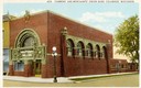
| Date: | 1930 |
|---|---|
| Description: | Farmers' and Merchants' Union Bank on a street corner. Designed by Louis Sullivan. Caption reads: "Farmers' and Merchants' Union Bank, Columbus, Wisconsin.... |
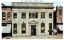
| Date: | 1915 |
|---|---|
| Description: | First National Bank, founded in 1861. Caption reads: "First National Bank, Columbus, Wis." |
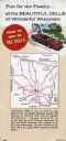
| Date: | |
|---|---|
| Description: | Back fold of a Wisconsin Dells promotional brochure featuring a simplified Wisconsin highway map with directions to the Dells, and a drawing of a family dr... |
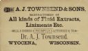
| Date: | |
|---|---|
| Description: | Advertising card for Dr. Townsend & Sons of Wyocena, manufacturers of all kinds of fluid extracts, liniments, etc. |

| Date: | |
|---|---|
| Description: | Postcard of the Hiawatha bar at Stanton's Palm Garden. There is a triangular bar at the center, and tables and chairs lining the walls. There are multiple... |

| Date: | 1905 |
|---|---|
| Description: | Shows railroads, roads, post offices, creeks, lakes, and cities. Includes chart of deposits and total resources from the years 1890 to 1905. "First Natio... |

| Date: | 1877 |
|---|---|
| Description: | Shows land ownership by name, churches, schools, farm houses, wagon roads, railroads. Includes directory of businesses for Columbus, Portage, Doylestown, W... |

| Date: | 1950 |
|---|---|
| Description: | Color postcard of the Farmers' and Merchants' Union Bank. The building was designed by Louis H. Sullivan and constructed in 1919 of Crawfordsville brick an... |

| Date: | 11 21 1950 |
|---|---|
| Description: | This map shows agricultural, residence, business, and industrial districts as well as lot and block numbers. |

| Date: | 1914 |
|---|---|
| Description: | This photostat map shows Fort Winnebago around 1931, land to be reserved for military purposes, roads to Fort Howard and Fort Crawford, "private property" ... |

| Date: | 1900 |
|---|---|
| Description: | This map shows landownership, churches, schools, farm houses, wagon roads, railroads, and townships and includes businesses advertisements, tables of stati... |
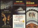
| Date: | |
|---|---|
| Description: | Outside of a Stand Rock Indian Ceremonial brochure. It contains information, prices and directions about the Indian Ceremonials at Stand Rock. The brochure... |
| Date: | |
|---|---|
| Description: | Inside of a Stand Rock Indian Ceremonial brochure. It contains information, prices and directions about the Indian Ceremonials at Stand Rock. The brochure ... |

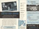
| Date: | 07 15 1968 |
|---|---|
| Description: | Text on reverse reads: "Country Kitchen. Wisconsin's Most Unique. A Dinner or a Snack – Plenty of Parking. Location: Hwy. 13 Exit on I-90-94 at intersectio... |
If you didn't find the material you searched for, our Library Reference Staff can help.
Call our reference desk at 608-264-6535 or email us at: