Filter: Categories of Wisconsin Historical Images
Filter: FORMAT_TYPE of prints, photomechanical
Filter: Subject of cities and towns
Filter: Categories of Wisconsin Historical Images
Filter: FORMAT_TYPE of prints, photomechanical
Filter: Subject of cities and towns

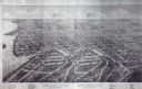
| Date: | 1896 |
|---|---|
| Description: | Bird's-eye view of Washburn, with twenty vignettes around side, water in foreground with docks and lumber corral. Thirty-three locations identified in key ... |

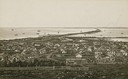
| Date: | 1910 |
|---|---|
| Description: | Bird's-eye view looking east, with Washburn Harbor at center and Chequamegon Bay in Lake Superior covering most of the upper image. Streets with buildings... |

| Date: | 1874 |
|---|---|
| Description: | Bird's-eye view of Waukesha, looking southwest, with insets of State Industrial School, Court House, and Fountain Spring House. |

| Date: | 1879 |
|---|---|
| Description: | This map is a bird's-eye view of Wausau, the County Seat of Marathon County. The map features an index of points of interest. |

| Date: | 1892 |
|---|---|
| Description: | Bird's-eye view of West Bend, looking west. Milwaukee River flows across image just below center, with fairgrounds at bottom right and Maple street at top ... |

| Date: | 1870 |
|---|---|
| Description: | Bird's-eye view of Whitewater, with insets. |
| Date: | 1879 |
|---|---|
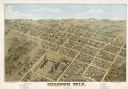
| Description: | Bird's-eye map of Beaver Dam. |

| Date: | 1890 |
|---|---|
| Description: | Colored bird's-eye map of Oconomowoc and the Lake Region, Waukesha County. Looking North from Government Hill. Location key below image identifies 24 Hotel... |
| Date: | 1942 |
|---|---|
| Description: | Trees interspersed with college buildings in lower half of image, with Fox River bisecting the middle, and a few buildings across the river with open fiel... |

| Date: | 1949 |
|---|---|
| Description: | Color bird's-eye map of the University of Wisconsin-Madison as it was midcentury, with two co-eds, several photographs of campus landmarks around edges, an... |

| Date: | 1948 |
|---|---|
| Description: | Colored map with black and white photographic images in wedges at right and left sides. Map extends from Camp Randal stadium at bottom left corner, to Lake... |
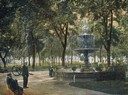
| Date: | |
|---|---|
| Description: | Colorized view of the Capitol Park and the replica of Centennial fountain installed in the park in 1878. The green paint is a change made in 1898. |
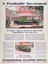
| Date: | 1930 |
|---|---|
| Description: | Advertising poster for the International Six-Speed Special truck (Model AW-2). Includes color illustrations of the truck on delivering goods to a storefron... |

| Date: | 1887 |
|---|---|
| Description: | Bird's-eye view of the Wisconsin Fish Hatchery at Fitchburg. |
| Date: | |
|---|---|
| Description: | Embossed souvenir postcard decorated with gold that depicts the third Wisconsin State Capitol as it appeared, 1883-1904. The gold dome was an entirely arti... |
If you didn't find the material you searched for, our Library Reference Staff can help.
Call our reference desk at 608-264-6535 or email us at: