Filter: Categories of Wisconsin Historical Images
Filter: FORMAT_TYPE of prints, photomechanical
Filter: Subject of botany
Filter: Subject of landforms
Filter: Categories of Wisconsin Historical Images
Filter: FORMAT_TYPE of prints, photomechanical
Filter: Subject of botany
Filter: Subject of landforms

| Date: | 1835 |
|---|---|
| Description: | Little Lake Butte Des Morts just north of Lake Winnebago where Governor Lewis Cass of Michigan, and Thomas McKenney, head of the Bureau of Indian Affairs (... |

| Date: | 1821 |
|---|---|
| Description: | Engraving of the Pictured Rocks shoreline viewed from Lake Superior. |

| Date: | 1832 |
|---|---|
| Description: | Junction of the Yellowstone River and the Missouri River. |

| Date: | 1867 |
|---|---|
| Description: | Birds-eye drawing of Appleton, Outagamie Co., depicting street names and street layout, houses, the Fox River, the court house, jail, school houses, Lawren... |

| Date: | 1878 |
|---|---|
| Description: | Bird's-eye map of Chilton with insets of points of interest, including P.H. Becker's Brewery, Chilton House, and Gutheil's Block. |

| Date: | 1877 |
|---|---|
| Description: | Bird's-eye map of Janesville on the Rock River. |

| Date: | 1871 |
|---|---|
| Description: | Birds eye map of Monroe, WI, depicts street names and street locations, houses, and trees. A reference key at the bottom of the map shows the locations of ... |

| Date: | 1870 |
|---|---|
| Description: | Birds-eye drawing of Oconomowoc depicts street names and street layouts, houses, trees, Oconomowoc River, Fowler Lake, and La Belle Lake. A reference key a... |

| Date: | 1875 |
|---|---|
| Description: | Bird's-eye map of Platteville. |

| Date: | 1829 |
|---|---|
| Description: | Drawing of Cassville depicting a horse cart on the river's edge, with men and boats. |
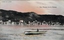
| Date: | 1905 |
|---|---|
| Description: | View of Alma across the Mississippi River, with a man in a rowboat in the foreground. Caption reads: "Alma, Wisconsin, from the Mississippi." |

| Date: | 1955 |
|---|---|
| Description: | Artist's conception of ancient village of Aztalan, fortified with high walls surrounding it. |
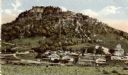
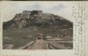
| Date: | 1901 |
|---|---|
| Description: | Grand Dad Bluff in La Crosse with the Crusher building which was built in 1901 and burned in 1902. Caption reads: "Grand Dad Bluff, La Crosse, Wis." |
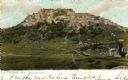
| Date: | |
|---|---|
| Description: | View from road towards farm buildings at the base of the bluff. A horse-drawn vehicle is on the rod. Caption reads: "Grand Dad's Bluff, La Crosse, Wis." |

| Date: | 1900 |
|---|---|
| Description: | Elevated view of La Crosse. Caption reads: "Panorama of La Crosse, Wis. from Grand Dad's Bluff." |
| Date: | 1905 |
|---|---|
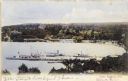
| Description: | Elevated view of Lake Geneva Bay, with assorted homes and hotels, and boats docked at long piers. Caption reads: "Geneva Bay, Lake Geneva, Wis." |

| Date: | 1960 |
|---|---|
| Description: | Aerial view with docks in the foreground. Caption reads: "Superior, Wisconsin." |

| Date: | 1905 |
|---|---|
| Description: | The view of the Lake Front from across the Mississippi River. Caption reads: "Lake Front at Maiden Rock, Wis." |

| Date: | 1839 |
|---|---|
| Description: | Shows locations of cities, towns, villages, post hamlets, canals, rail and stage roads. Includes table of steamboat routes and distances; vignette of "Maid... |
If you didn't find the material you searched for, our Library Reference Staff can help.
Call our reference desk at 608-264-6535 or email us at: