 Filter: Categories of Wisconsin Historical Images
Filter: FORMAT_TYPE of prints, photomechanical
Filter: Reproduction Rights of For Sale
Filter: Subject of battlefields
Filter: Categories of Wisconsin Historical Images
Filter: FORMAT_TYPE of prints, photomechanical
Filter: Reproduction Rights of For Sale
Filter: Subject of battlefields
| Date: | |
|---|---|
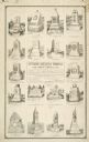
| Description: | An advertisement by the Smith Granite Company showing illustrations of various Gettysburg Battleground Memorials. |

| Date: | 1885 |
|---|---|
| Description: | Chromolithograph advertising poster produced for the McCormick Harvesting Machine Company showing a McCormick binder stored in a shed in the middle of the ... |
| Date: | 01 07 1855 |
|---|---|
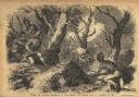
| Description: | Sketch of the defeat of General Braddock during an ambush in the French and Indian War. Caption reads: "Defeat of General Braddock, in the French and India... |

| Date: | |
|---|---|
| Description: | Plan of the battle of the horse shoe bend on the East Pecatonica. |

| Date: | 1814 |
|---|---|
| Description: | Scale: about 43 miles to 1 in. Boundaries colored. |
| Date: | 08 1862 |
|---|---|
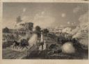
| Description: | Color lithograph of Union lines in the midst of battle. |
| Date: | |
|---|---|
| Description: | Engraving excerpted from John S.C. Abbott's History of the Civil War in America. |
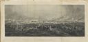
| Date: | |
|---|---|
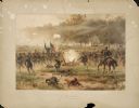
| Description: | An engraving after the painting by James Walker of the Battle of Gettysburg. |
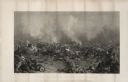
| Date: | 1863 |
|---|---|
| Description: | An engraving of the Battle of Gettysburg, after the painting by P.F. Rothermel. |
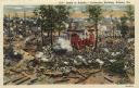
| Date: | |
|---|---|
| Description: | Color postcard of a section of the cyclorama painting "Battle of Atlanta" executed by painters under Wilhem Wehner in the 1880s. This scene shows the fight... |
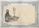
| Date: | 1860 |
|---|---|
| Description: | "Cain" standing in foreground of battlefield attracting the smoke of secession, as the Union smoke goes into the air. "Cain" refers to the Marshall of Poli... |
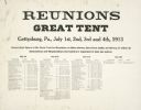
| Date: | 07 1913 |
|---|---|
| Description: | A broadside listing regimental functions at the Gettysburg reunion of Union veterans held at Gettysburg, Pennsylvania, July 1st, 2nd, 3rd, 4th, 1913. |
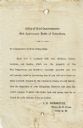
| Date: | 07 1913 |
|---|---|
| Description: | A broadside to the Commanders of State Delegations from J.E. Normoyle, Major Q.M. Corps, Chief Q.M., stating the contents of each tent at the 50th Annivers... |

| Date: | 1942 |
|---|---|
| Description: | Advertising proof illustrating International Harvester's contribution to the war effort through the forming of maintenance battalions to service Internatio... |

| Date: | 1864 |
|---|---|
| Description: | (U.S. 39th Cong. 1stt Sess. Report of Chief engineer) The legend in the upper left corner contains a brief resume of each day's action while the map sho... |

| Date: | 1864 |
|---|---|
| Description: | This map of the Battle of Gettysburg indicates Union positions in red and Confederate positions in blue. Also shown are artillery positions, roads, railroa... |

| Date: | 1861 |
|---|---|
| Description: | This map was reproduced photographically and issued in Augusta, Ga., in the early days of the Civil War. It includes panels showing Virginia, Maryland, the... |

| Date: | 1861 |
|---|---|
| Description: | This map shows Manassas during the First Battle of Bull Run, in which the 2nd Wisconsin Infantry fought, and the Leesburg area, the site of the Battle of B... |

| Date: | 1876 |
|---|---|
| Description: | Detailed topographic map of the Gettysburg battlefield created thirteen years after the battle. This map shows day one of the battle. The map shows drainag... |

| Date: | 1862 |
|---|---|
| Description: | This map illustrates the official plan for the siege of Yorktown, Virginia, and indicates the headquarters of Generals McClellan, Porter, Woodbury, and Hei... |
If you didn't find the material you searched for, our Library Reference Staff can help.
Call our reference desk at 608-264-6535 or email us at: