Filter: Categories of Wisconsin Historical Images
Filter: FORMAT_TYPE of prints, photomechanical
Filter: County of Sauk
Filter: Year of 1800-1899
Filter: Categories of Wisconsin Historical Images
Filter: FORMAT_TYPE of prints, photomechanical
Filter: County of Sauk
Filter: Year of 1800-1899

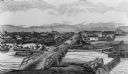
| Date: | 1870 |
|---|---|
| Description: | Baraboo was first settled around 1838, and by 1870 it had become the county seat and the thriving village illustrated here. This birds eye drawing depicts ... |

| Date: | 1870 |
|---|---|
| Description: | Bird's-eye map of Prairie du Sac. |

| Date: | 1870 |
|---|---|
| Description: | Sauk City is the oldest incorporated village in Wisconsin (incorporated in 1854) and also has the oldest organized volunteer fire department in the state, ... |

| Date: | 1883 |
|---|---|
| Description: | Bird's-eye map of Prairie du Sac, Wisconsin with an inset of Clifton. |

| Date: | 1883 |
|---|---|
| Description: | Bird's-eye map of Sauk City. |
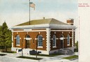
| Date: | 1895 |
|---|---|
| Description: | Elevated view across street towards the post office. Caption reads: "Post Office, Baraboo, Wis." |
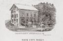
| Date: | 1880 |
|---|---|
| Description: | Exterior view of a mill, with several figures and horse-drawn vehicles located around it. Caption reads: "Sauk City Mills." |
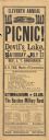
| Date: | 1889 |
|---|---|
| Description: | An original poster advertising the eleventh annual railroad picnic, taking place at Devil's Lake State Park on Saturday, July 27, 1889. In the advertiseme... |

| Date: | 1877 |
|---|---|
| Description: | This 1877 map of Sauk County, Wisconsin, shows the township and range grid, sections, towns, cities and villages, land ownership and acreages, wagon roads,... |

| Date: | 01 01 1852 |
|---|---|
| Description: | These manuscript maps, drawn by William H. Canfield in 1852, illustrate mounds primarily in Sauk County, Wisconsin, in the towns of Greenfield, La Valle, M... |

| Date: | 09 1893 |
|---|---|
| Description: | Shows townships and sections, landownership and acreages, buildings, and school districts. Includes vignettes of local buildings, business directory, list ... |
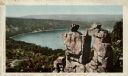
| Date: | 1898 |
|---|---|
| Description: | Colorized postcard view of the Devil's Doorway rock formation overlooking Devil's Lake. Caption reads: "Devil's Doorway, Devil's Lake, Wis." |

| Date: | 07 1870 |
|---|---|
| Description: | This map of Ironton is pen-and-ink on paper and shows lots and block numbers, mill, foundry buildings, limestone quarry, iron mine, and roads. Relief is sh... |

| Date: | 07 1892 |
|---|---|
| Description: | Engraved illustration depicting Frank Lenz sitting on the edge of a railroad bridge holding his safety bicycle in front of him and his box camera on his ba... |

| Date: | 1861 |
|---|---|
| Description: | This map shows townships and sections, landownership, roads, railroads, rural residences, schools, churches, and topography. Also included are inset maps o... |
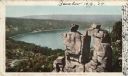
| Date: | 1898 |
|---|---|
| Description: | Colorized postcard of an elevated view of the Devil's Doorway rock formation at Devil's Lake State Park. Devil's Lake is below in the background. Caption r... |

| Date: | 1892 |
|---|---|
| Description: | A Sanborn fire insurance map of Sauk City which was drawn up in 1892. |
If you didn't find the material you searched for, our Library Reference Staff can help.
Call our reference desk at 608-264-6535 or email us at: