 Filter: Categories of Wisconsin Historical Images
Filter: FORMAT_TYPE of prints, photomechanical
Filter: County of Sauk
Filter: Subject of wisconsin river (wis.)
Filter: Categories of Wisconsin Historical Images
Filter: FORMAT_TYPE of prints, photomechanical
Filter: County of Sauk
Filter: Subject of wisconsin river (wis.)

| Date: | 1870 |
|---|---|
| Description: | Bird's-eye map of Prairie du Sac. |

| Date: | 1870 |
|---|---|
| Description: | Sauk City is the oldest incorporated village in Wisconsin (incorporated in 1854) and also has the oldest organized volunteer fire department in the state, ... |

| Date: | 1883 |
|---|---|
| Description: | Bird's-eye map of Prairie du Sac, Wisconsin with an inset of Clifton. |

| Date: | 1883 |
|---|---|
| Description: | Bird's-eye map of Sauk City. |
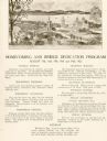
| Date: | 1922 |
|---|---|
| Description: | Homecoming and bridge dedication program, featuring an image of the approach to the Wisconsin River Bridge, and a listing of the celebration's planned even... |
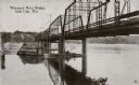
| Date: | 1910 |
|---|---|
| Description: | View from below along the left side of the Wisconsin River bridge. Tree-covered hills are on the opposite shoreline. Caption reads: "Wisconsin River Bridge... |

| Date: | 1910 |
|---|---|
| Description: | This was the first bridge built across the Wisconsin River, constructed about 1850, although it was not opened to traffic until 1852. It was torn down in 1... |
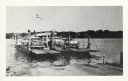
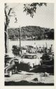
| Date: | |
|---|---|
| Description: | The Merrimac ferry loaded with automobiles. There is an American flag flying on the ferry. |
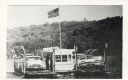
| Date: | |
|---|---|
| Description: | The Merrimac ferry "Colsac" with an American flag. |
| Date: | |
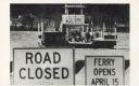
|---|---|
| Description: | The Merrimac ferry "Colsac II" is seen on the Wisconsin River behind two signs. The signs read, "Road Closed" and "Ferry Opens April 15". |
| Date: | |
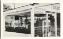
|---|---|
| Description: | A close view of the Merrimac ferry "Colsac I" with a sign reading, "Stop Your Motor When Ferry Is Moving". |
| Date: | |
|---|---|
| Description: | Automobiles line up to wait for the Merrimac ferry "Colsac". |
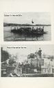
| Date: | |
|---|---|
| Description: | Two images of ferries as printed on a postcard. The top image is the ferry "Colsac" on the Wisconsin River. The bottom image is simply described as an earl... |

| Date: | 1912 |
|---|---|
| Description: | This outline map of Sauk County, Wisconsin, shows the towns, cities and villages, railroads, and streams in the county. |

| Date: | 1877 |
|---|---|
| Description: | This 1877 map of Sauk County, Wisconsin, shows the township and range grid, sections, towns, cities and villages, land ownership and acreages, wagon roads,... |

| Date: | 1939 |
|---|---|
| Description: | This map of Sauk County, Wisconsin, shows the township and range grid, towns, sections, cities and villages, roads, railroads, lakes and rivers, schools, a... |
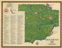
| Date: | 1975 |
|---|---|
| Description: | This 1975 map of Sauk County, Wisconsin, lists and locates historic sites and other points of interest in the county. |

| Date: | 1990 |
|---|---|
| Description: | This late 20th century tourist map of Sauk County, Wisconsin, shows the highways and roads, cities and towns, parks, airports, canoe landings, hospitals, s... |

| Date: | 1948 |
|---|---|
| Description: | This outline map of Sauk County, Wisconsin, shows the towns, cities and villages, railroads, and streams in the county. |

| Date: | 1915 |
|---|---|
| Description: | This 1915 map covers the section of the Wisconsin River in southern Adams, southeastern Juneau, northeastern Sauk, and northwestern Columbia counties. A po... |
If you didn't find the material you searched for, our Library Reference Staff can help.
Call our reference desk at 608-264-6535 or email us at: