Filter: Categories of Wisconsin Historical Images
Filter: FORMAT_TYPE of prints, photomechanical
Filter: County of Sauk
Filter: Subject of roads
Filter: Categories of Wisconsin Historical Images
Filter: FORMAT_TYPE of prints, photomechanical
Filter: County of Sauk
Filter: Subject of roads

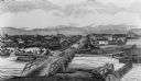
| Date: | 1870 |
|---|---|
| Description: | Baraboo was first settled around 1838, and by 1870 it had become the county seat and the thriving village illustrated here. This birds eye drawing depicts ... |

| Date: | 1870 |
|---|---|
| Description: | Bird's-eye map of Prairie du Sac. |

| Date: | 1870 |
|---|---|
| Description: | Sauk City is the oldest incorporated village in Wisconsin (incorporated in 1854) and also has the oldest organized volunteer fire department in the state, ... |

| Date: | 1883 |
|---|---|
| Description: | Bird's-eye map of Prairie du Sac, Wisconsin with an inset of Clifton. |
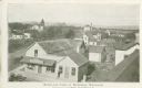
| Date: | 1900 |
|---|---|
| Description: | Elevated view of commercial buildings, houses, a church and a school in a neighborhood. In the foreground a person is standing at the side of a building wi... |
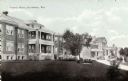
| Date: | 1920 |
|---|---|
| Description: | View across lawn towards buildings. Caption reads: "County Farm, Reedsburg, Wis." |
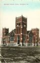
| Date: | 1905 |
|---|---|
| Description: | Exterior view of the Methodist Episcopal church. Caption reads: "Methodist Episcopal Church, Reedsburg, Wis." |

| Date: | |
|---|---|
| Description: | Map of Baraboo and its surroundings, showing the ancient mound city, the water power, and thoroughfares, drawn by William H. Canfield. Canfield includes sk... |
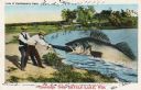
| Date: | 07 28 1933 |
|---|---|
| Description: | Colorized postcard in the Tall-Tale style. Two men standing on the shore are pulling a third man's leg out of a enormous fish's mouth. Two automobiles and ... |
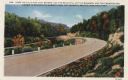
| Date: | 1933 |
|---|---|
| Description: | Colorized postcard of a paved road curving to the left through trees, shrubs and bluffs. A dirt road can be seen to the left, and the sky is blue with a fe... |

| Date: | 1914 |
|---|---|
| Description: | Colorized postcard of the rock formation called the Devil's Doorway in Devil's Lake State Park. Trees can be seen below. The lake, bluffs, roads and buildi... |

| Date: | 12 29 1909 |
|---|---|
| Description: | Colorized postcard of the rock formation called the Devil's Doorway in Devil's Lake State Park. Trees are on the left and below. Bluffs, trees, sky and a r... |
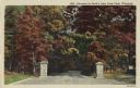
| Date: | 1946 |
|---|---|
| Description: | Colorized postcard of the entrance to Devil's Lake State Park. Trees and foliage fill the scene and it appears to be autumn. Stone pillars are on either si... |

| Date: | 06 28 1912 |
|---|---|
| Description: | Colorized postcard view of the rock formation called the Devil's Doorway in Devil's Lake State Park. Trees are growing among the rocks. The lake, bluffs, b... |
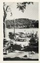
| Date: | |
|---|---|
| Description: | Automobiles line up to wait for the Merrimac ferry "Colsac". |

| Date: | 1877 |
|---|---|
| Description: | This 1877 map of Sauk County, Wisconsin, shows the township and range grid, sections, towns, cities and villages, land ownership and acreages, wagon roads,... |

| Date: | 1939 |
|---|---|
| Description: | This map of Sauk County, Wisconsin, shows the township and range grid, towns, sections, cities and villages, roads, railroads, lakes and rivers, schools, a... |

| Date: | 1990 |
|---|---|
| Description: | This late 20th century tourist map of Sauk County, Wisconsin, shows the highways and roads, cities and towns, parks, airports, canoe landings, hospitals, s... |

| Date: | 1920 |
|---|---|
| Description: | This map of Devil's Lake State Park in Sauk County, Wisconsin, shows the park limits, railroads, roads, creeks, trails, and points of interest in the area.... |
If you didn't find the material you searched for, our Library Reference Staff can help.
Call our reference desk at 608-264-6535 or email us at: