 Filter: Categories of Wisconsin Historical Images
Filter: FORMAT_TYPE of prints, photomechanical
Filter: County of Rock
Filter: Categories of Wisconsin Historical Images
Filter: FORMAT_TYPE of prints, photomechanical
Filter: County of Rock
| Date: | |
|---|---|
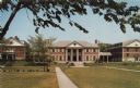
| Description: | Photographic postcard view across lawn towards the women's dorms at Beloit College. |

| Date: | |
|---|---|
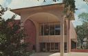
| Description: | Photographic postcard view of the student union on the Beloit College Campus. |
| Date: | |
|---|---|
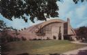
| Description: | Photographic postcard view of the exterior of the Field House arena on the Beloit College campus. |
| Date: | 1965 |
|---|---|
| Description: | Photographic postcard of the exterior view of the Colonel Robert H. Morse Library at Beloit College. |

| Date: | 1908 |
|---|---|
| Description: | Colorized postcard view of a log cabin with a front porch and vines growing on the side. Caption reads: "Log House on River Road, Beloit, Wis." |

| Date: | 1973 |
|---|---|
| Description: | This map is a photocopy of the original plat of Beloit from 1838. The map shows labeled roads, lots, and rivers. |
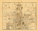
| Date: | 1887 |
|---|---|
| Description: | This map of Beloit shows labeled wards, plat of town, roads, railroads, the Rock River, city boundaries, and land ownership by name. The back of the map is... |
| Date: | 1952 |
|---|---|
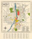
| Description: | This colorful map of Beloit shows roads, railroads, rivers, creeks, business districts, industrial areas, and parks and recreation areas. The map includes ... |
| Date: | 1953 |
|---|---|
| Description: | This map of Beloit shows existing platted streets or highways and proposed street right of way. The map reads: "I hereby certify that this is the official ... |

| Date: | 1860 |
|---|---|
| Description: | Map showing a plat of the city, land ownership by name, wards by number, local streets, buildings, fair grounds, nurseries, and part of Rock River. The map... |
| Date: | 1927 |
|---|---|
| Description: | This map shows a plat of city, a numbering system, local streets, railroads, and part of the Rock River. The map is indexed by street name and reads: "Copy... |

| Date: | 1873 |
|---|---|
| Description: | This map shows landownership and acreages, lot and block numbers, roads and railroads, marshes, schools, churches, mills, rural buildings, and quarries. Re... |

| Date: | 1955 |
|---|---|
| Description: | This map includes a street index and shows municipal golf course, parks, schools, cemeteries, Janesville County Club, and industrial sites. The back of the... |

| Date: | 1900 |
|---|---|
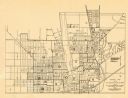
| Description: | This map includes an index of streets and schools, and shows parks and public lands, as well as industrial sites. |

| Date: | 1973 |
|---|---|
| Description: | This map includes an index of streets and schools and also shows parks, schools and public lands, and industrial sites. Portions of the map are in green an... |

| Date: | 1900 |
|---|---|
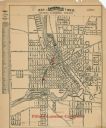
| Description: | This map is indexed and shows numbering system, public buildings and parks, wards, and voting booths. |

| Date: | 1850 |
|---|---|
| Description: | This map shows a plat of the town, land owners by name, local streets, railroads, churches, and part of the Rock River. The map is also indexed by church d... |

| Date: | 1873 |
|---|---|
| Description: | This map shows land ownership by name, local streets, railroads, parks, college grounds, schools, cemeteries, and part of Rock River. The upper left margin... |
| Date: | 1860 |
|---|---|
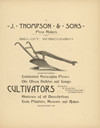
| Description: | Advertisement for plows, cultivators, harrows, corn planters, mowers, rakes, sulkies and gangs. |
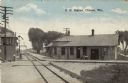
| Date: | 1910 |
|---|---|
| Description: | Colorized postcard view of the railroad station yard master's tower. Caption reads: "R. R. Station, Clinton, Wis." |
If you didn't find the material you searched for, our Library Reference Staff can help.
Call our reference desk at 608-264-6535 or email us at: