 Filter: Categories of Wisconsin Historical Images
Filter: FORMAT_TYPE of prints, photomechanical
Filter: County of Rock
Filter: Subject of railroads
Filter: Categories of Wisconsin Historical Images
Filter: FORMAT_TYPE of prints, photomechanical
Filter: County of Rock
Filter: Subject of railroads

| Date: | 1877 |
|---|---|
| Description: | Bird's-eye map of Janesville on the Rock River. |

| Date: | 1881 |
|---|---|
| Description: | Bird's-eye map of Milton Junction. |
| Date: | 1905 |
|---|---|
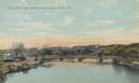
| Description: | Elevated view of the river, with railroad tracks on the left shoreline, and a railroad bridge crossing the river. Caption reads: "View of River from Grand ... |
| Date: | |
|---|---|
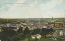
| Description: | Elevated view of the plant and residential area, with smokestacks. Caption reads: "Birds-eye View of Fairbanks Morse Plant, Beloit, Wis." |

| Date: | 1858 |
|---|---|
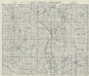
| Description: | This 1858 map of Rock County, Wisconsin, shows the township and range grid, towns, sections, cities and villages, railroads, roads, property owners and res... |

| Date: | 1853 |
|---|---|
| Description: | Map covers area between the cities of Janesville and Kenosha in Rock, Walworth, and Kenosha counties for railroad routes. Lakes and counties are labelled. ... |
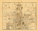
| Date: | 1887 |
|---|---|
| Description: | This map of Beloit shows labeled wards, plat of town, roads, railroads, the Rock River, city boundaries, and land ownership by name. The back of the map is... |
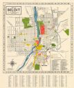
| Date: | 1952 |
|---|---|
| Description: | This colorful map of Beloit shows roads, railroads, rivers, creeks, business districts, industrial areas, and parks and recreation areas. The map includes ... |
| Date: | 1927 |
|---|---|
| Description: | This map shows a plat of city, a numbering system, local streets, railroads, and part of the Rock River. The map is indexed by street name and reads: "Copy... |

| Date: | 1873 |
|---|---|
| Description: | This map shows landownership and acreages, lot and block numbers, roads and railroads, marshes, schools, churches, mills, rural buildings, and quarries. Re... |

| Date: | 1850 |
|---|---|
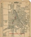
| Description: | This map shows a plat of the town, land owners by name, local streets, railroads, churches, and part of the Rock River. The map is also indexed by church d... |

| Date: | 1873 |
|---|---|
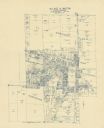
| Description: | This map shows land ownership by name, local streets, railroads, parks, college grounds, schools, cemeteries, and part of Rock River. The upper left margin... |
| Date: | 1960 |
|---|---|
| Description: | This blue line print map shows lot and block numbers and dimensions, some landownership, roads, and railroads. The map includes manuscript annotations of a... |
| Date: | 1955 |
|---|---|
| Description: | This cadastral map shows highways, land owners, railroads, and rivers. |
If you didn't find the material you searched for, our Library Reference Staff can help.
Call our reference desk at 608-264-6535 or email us at:
