 Filter: Categories of Wisconsin Historical Images
Filter: FORMAT_TYPE of prints, photomechanical
Filter: County of Jefferson
Filter: Categories of Wisconsin Historical Images
Filter: FORMAT_TYPE of prints, photomechanical
Filter: County of Jefferson
| Date: | |
|---|---|
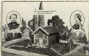
| Description: | Artist's rendering of an elevated view of the first kindergarten, with children and a teacher gathered in front of the building. There are inset portraits ... |
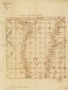
| Date: | 1860 |
|---|---|
| Description: | This manuscript map shows the surveyed areas of the Town of Aztalan, Jefferson County, Wisconsin. Acreage of the surveyed parcels is given and lakes and st... |

| Date: | 1870 |
|---|---|
| Description: | Bird’s-eye view map. "Looking north east." Indexed for points of interest. Shows homes, businesses, and the Bark and Rock River. Streets running west to ea... |

| Date: | 1920 |
|---|---|
| Description: | Shows ward boundaries, corporation limits, plat of town, land ownership by name, local streets, parks, railroads, and parts of Rock River. Wards appear in ... |

| Date: | 1947 |
|---|---|
| Description: | Lower left hand corner features a legend. "Drawn 1938, revised 1947." Shows water mains, hydrants, corporation limits, city ward divisions, fire proof buil... |

| Date: | 1976 |
|---|---|
| Description: | Includes index of streets and of local businesses. Shows location of Citizens State Bank, roads, highways, railroads, parks, cemeteries, and city sanitary ... |

| Date: | 1911 |
|---|---|
| Description: | Map shows in blue roads, railroads, post offices, schools, houses, churches, and routes. The map includes a chart of "Explanation" that acts as a legend. T... |

| Date: | 1872 |
|---|---|
| Description: | Map shows townships and sections, landownership, roads, railroads, churches, schools, and cemeteries. The map includes business directories of Watertown, J... |
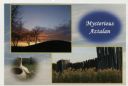
| Date: | |
|---|---|
| Description: | Photographic postcard view of three views from Aztalan State Park; Indian Mound at sunset, pottery, and a fence. |
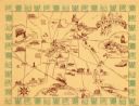
| Date: | 1940 |
|---|---|
| Description: | This map of Watertown pictorially shows historic buildings, locations, and events with dates. The map is printed in brown ink with the border printed in gr... |

| Date: | 1940 |
|---|---|
| Description: | This map of Aztalan is pencil and ink on paper. The map shows streets, local businesses, churches, houses, and the Crawfish River. The map reads: "Informat... |

| Date: | 1887 |
|---|---|
| Description: | This map shows landownership, lot and block numbers, wards, cemeteries, and the high school. The map has been removed from Page’s Atlas of Jefferson County... |

| Date: | 06 1959 |
|---|---|
| Description: | This blue line print map shows lot and block numbers and dimensions, fair grounds, schools, court house, parks, and the street numbering system. The Crawfi... |
| Date: | |
|---|---|
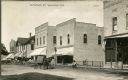
| Description: | View across Jefferson Street toward several storefronts and horse-drawn vehicles on the right. Near the Gustave [__]ner Harness Shop is a man seated on a w... |
| Date: | |
|---|---|
| Description: | Partially colorized postcard view down Jefferson Street. People are gathered in front of one of the storefronts on the right, and horse-drawn vehicles are ... |

| Date: | 1857 |
|---|---|
| Description: | This map shows lot and block numbers, buildings, some land ownership, wards, waterways, streets, railroads, brick yards, and cemeteries. It includes an ind... |

| Date: | 1950 |
|---|---|
| Description: | The Lorenzo Dow Fargo Public Library building is partially obscured by trees in this photographic postcard. The stone, Gothic revival building has a centra... |
| Date: | 1904 |
|---|---|
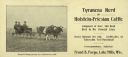
| Description: | An advertising card includes a photograph of a man in an open carriage holding the reins of a team of Holstein-Friesian cattle. Two well-dressed men are si... |

| Date: | 1912 |
|---|---|
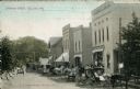
| Description: | Photographic postcard view down the center of a unpaved street in downtown Fort Atkinson. Horse-drawn vehicles are at the curbs. Caption reads: "Street Sce... |

| Date: | 1913 |
|---|---|
| Description: | Hand-colored scene of north Main Street lined with businesses. There are horse-drawn vehicles in the unpaved street. Caption reads: "N. Main Street, Ft. At... |
If you didn't find the material you searched for, our Library Reference Staff can help.
Call our reference desk at 608-264-6535 or email us at: