Filter: Categories of Wisconsin Historical Images
Filter: FORMAT_TYPE of prints, photomechanical
Filter: County of Dane
Filter: Categories of Wisconsin Historical Images
Filter: FORMAT_TYPE of prints, photomechanical
Filter: County of Dane

| Date: | 1855 |
|---|---|
| Description: | Part of George Harrison's "Map of the City of Madison," showing the development of the isthmus and the small size of the second Capitol (54' x 104') in com... |

| Date: | 1896 |
|---|---|
| Description: | A portion of John B. Heim's map of the Water Works System of Madison showing the size of the third Wisconsin Capitol (228' x 226') in comparison with the C... |
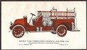
| Date: | 1919 |
|---|---|
| Description: | Advertising card for a double tank combination chemical and hose car on an International Harvester Model H 1919 commercial truck chassis featuring color il... |
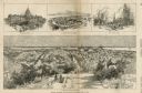
| Date: | 03 30 1889 |
|---|---|
| Description: | Bird's-eye view from Bascom Hill of Madison, with vignettes of the Wisconsin State Capitol, Lake Monona, and the Capitol Park. |
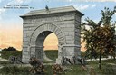
| Date: | 1912 |
|---|---|
| Description: | Camp Randall Memorial Arch and Civil War cannons. The memorial was built to honor Wisconsin Civil War soldiers and is located on the University of Wisconsi... |
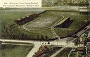
| Date: | 1908 |
|---|---|
| Description: | Aerial view of Camp Randall Stadium on the University of Wisconsin-Madison campus. Top image on Place File card. Caption reads: "Bird's-eye View, Camp Ra... |
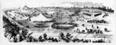
| Date: | 11 20 1858 |
|---|---|
| Description: | Panoramic sketch of the first Wisconsin State Fair held in Madison with large tents, fire companies, side-shows, and performances that drew thousands of vi... |
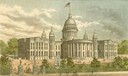
| Date: | 1887 |
|---|---|
| Description: | View of the third Wisconsin State Capitol from the pages of the Wisconsin Blue Book. |
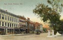
| Date: | 1909 |
|---|---|
| Description: | View of Main Street with streetcar. Caption reads: "Main Street, Madison, Wis." |
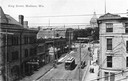
| Date: | 1904 |
|---|---|
| Description: | Looking down King Street with streetcar. A sign that reads, "Base Ball Today" is strung over the street and the Wisconsin State Capitol is in the backgroun... |
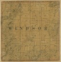
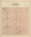
| Date: | 1861 |
|---|---|
| Description: | Dane County plat map of the town of Windsor. |

| Date: | 1905 |
|---|---|
| Description: | View of the high school in Deerfield. Caption reads: "High School, Deerfield, Wis." |
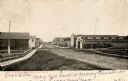
| Date: | 1905 |
|---|---|
| Description: | View down side of unpaved Main Street in Deerfield, with a wooden sidewalk on the left. Caption reads: "Main Street, Deerfield, Wis." Handwritten note: "De... |
| Date: | 1905 |
|---|---|
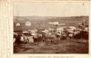
| Description: | Elevated view of the town. Caption reads: "Part of Deerfield, Wis. -- viewed from the East". Handwritten note: "Dear Ella, Here comes the postal I am owing... |

| Date: | 1911 |
|---|---|
| Description: | Plat Map of Blooming Grove in "Atlas of Dane County, Wisconsin." |
| Date: | |
|---|---|
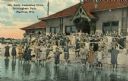
| Description: | A colorized image of a girls' swimming class at the Brittingham Park bathhouse. Caption reads: "Girls' Swimming Class, Brittingham Park, Madison, Wis." |
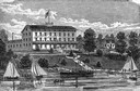
| Date: | 1948 |
|---|---|
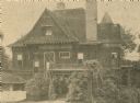
| Description: | The Buell home, built by Charles E. Buell in 1894, which was called "Buell's Folly" locally. |
| Date: | 1910 |
|---|---|
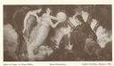
| Description: | Hugo Ballin's "Spirit of Labor" mural from the Wisconsin State Capitol building. Caption reads: "Spirit of Labor, by Hugo Ballin. Mural Decoration. Capitol... |
If you didn't find the material you searched for, our Library Reference Staff can help.
Call our reference desk at 608-264-6535 or email us at: