 Filter: Categories of Wisconsin Historical Images
Filter: FORMAT_TYPE of prints, photomechanical
Filter: County of Calumet
Filter: Categories of Wisconsin Historical Images
Filter: FORMAT_TYPE of prints, photomechanical
Filter: County of Calumet

| Date: | 1878 |
|---|---|
| Description: | Bird's-eye map of Chilton with insets of points of interest, including P.H. Becker's Brewery, Chilton House, and Gutheil's Block. |
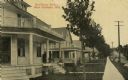
| Date: | 1915 |
|---|---|
| Description: | View down sidewalk of houses along the street. Caption reads: "Residence Street, New Holstein, Wis." |
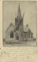
| Date: | 06 20 1907 |
|---|---|
| Description: | Black and white postcard of the German Methodist Episcopal Church. Caption reads: "German M.E. Church, near Brillion, Wis." |
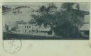
| Date: | 06 20 1907 |
|---|---|
| Description: | Postcard of North Main Street. Buildings line the right side of the street and there are several large trees along the sidewalk. Text below reads: "N. Main... |
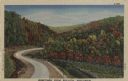
| Date: | 1947 |
|---|---|
| Description: | Colorized postcard of a paved road curving between hills with trees in autumn color. There are flowers in the fields on both sides of the road. Caption rea... |

| Date: | |
|---|---|
| Description: | Color postcard of a country road shaded by trees in autumn color. |

| Date: | |
|---|---|
| Description: | Color postcard of a man sitting on a stone wall along a road while enjoying a country scene. The road curves through the hills and the trees are starting t... |

| Date: | |
|---|---|
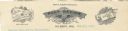
| Description: | Letterhead of the Chilton Branch of the Falk Jung & Borchert Brewing Company, headquartered in Milwaukee, Wisconsin. It includes, on the left, an elevated ... |
| Date: | |
|---|---|
| Description: | Memohead of the Post Office in Hilbert, Wisconsin, with a center image of an eagle holding a banner, the ends of which read U.S. and Mail, in its beak, und... |

| Date: | |
|---|---|
| Description: | Memohead of a newspaper originally published in Stockbridge as the "Union," but known as the "Wisconsin Demokrat" after its editor moved production to Chil... |
| Date: | 1919 |
|---|---|
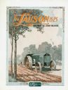
| Description: | Advertisement for the Lauson 15-25 tractor featuring a color illustration of a farmer using the tractor and plow in a field, surrounded by an Art Deco-styl... |
| Date: | 1919 |
|---|---|
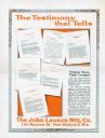
| Description: | Advertisement for the John Lauson Manufacturing Company featuring an illustration of testimonials from satisfied customers. The caption reads: "Output More... |
| Date: | 1920 |
|---|---|
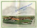
| Description: | Elevated-view illustration of the John Lauson Manufacturing Company factory. The company made Lauson tractors and Lauson Frost King gasoline engines. |

| Date: | 1920 |
|---|---|
| Description: | Advertisement for the Lauson 15-25 kerosene tractor with "21 jewel movement" Hyatt & Timken roller bearings. The advertisement features an illustration of ... |
| Date: | 1925 |
|---|---|
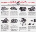
| Description: | Advertisement for Lauson gasoline and kerosene engines and tractors with a slogan reading: "Built Up to a Standard - Not Down to a Price." The advertisemen... |

| Date: | 1977 |
|---|---|
| Description: | This 1977 map identifies the locations of 46 cemeteries in Calumet County, Wisconsin. Cemeteries are indexed by town. Also included are a civil town map, a... |
| Date: | 1943 |
|---|---|
| Description: | Map shows the town of St. Catherine, Wisconsin, between Lake Street and Doty Street as it appeared on January 3, 1852. Map is situated facing north with La... |
| Date: | 1836 |
|---|---|
| Description: | This plat map shows the proposed Town of Whitesboro, a paper city (a city planned but never built), located on the Manitowoc River in Calumet County. Certi... |
| Date: | 1955 |
|---|---|
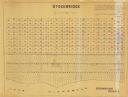
| Description: | This map shows landownership in the old Stockbridge Indian reservation on Lake Winnebago in Calumet County. The lots are numbered and labeled by owner. A b... |

| Date: | 1836 |
|---|---|
| Description: | This negative photostat map shows the "oak tree, place of beginning" on the division line between Stockbridge and Brothertown Indians, and Governor Porter'... |
If you didn't find the material you searched for, our Library Reference Staff can help.
Call our reference desk at 608-264-6535 or email us at: