 Filter: Categories of Wisconsin Historical Images
Filter: FORMAT_TYPE of prints, photomechanical
Filter: County of Bayfield
Filter: Year of 1900-1999
Filter: Categories of Wisconsin Historical Images
Filter: FORMAT_TYPE of prints, photomechanical
Filter: County of Bayfield
Filter: Year of 1900-1999

| Date: | 1910 |
|---|---|
| Description: | Bird's-eye view looking east, with Washburn Harbor at center and Chequamegon Bay in Lake Superior covering most of the upper image. Streets with buildings... |
| Date: | 1930 |
|---|---|
| Description: | View of the State Fish Hatchery. Caption reads: "State Fish Hatchery, near Ashland, Wis." |
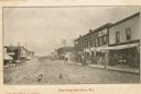
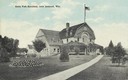
| Date: | 1907 |
|---|---|
| Description: | View down Main Street, including storefronts with signs advertising ice cream, baked goods, clothing and shoes. Caption reads: "Main Street, Iron River, Wi... |
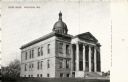
| Date: | 1905 |
|---|---|
| Description: | The Washburn Court House. Caption reads: "Court House, Washburn, Wis." |
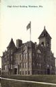
| Date: | 1920 |
|---|---|
| Description: | View across lawn towards the school building. Caption reads: "High School Building, Washburn, Wis." |
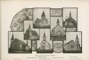
| Date: | 1904 |
|---|---|
| Description: | Composite photograph of views of seven Washburn churches, including Mehtodist Church, Swedish Mission Church, Congregational Church, Norwegian Lutheran Chu... |
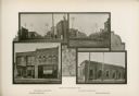
| Date: | 1904 |
|---|---|
| Description: | Composite photograph of four views of Washburn, including Main Street, looking West, Bayfield County Bank, Main Street, looking East, and Northern State Ba... |
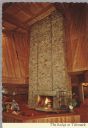
| Date: | 09 02 1975 |
|---|---|
| Description: | Color postcard of the interior of the Lodge at Telemark showing one of the largest stone fireplaces in the world. It is constructed out of 155 tons of nati... |

| Date: | 1909 |
|---|---|
| Description: | Postcard of the overhanging cliffs near the stone quarry on Presque Isle or Stockton Island's. Caption reads: "Apostle Islands, Wis. Presque Isle or Stockt... |

| Date: | 1968 |
|---|---|
| Description: | The map shows fire towers, public camp grounds, roads, snow mobile & riding trails, trout lakes, foot trails, railroads, and National Forest boundaries. |

| Date: | 1900 |
|---|---|
| Description: | This 1900 map shows the township and range system, sections, cities and villages, railroads, roads, vacant land and land sold by the Wisconsin Central Rail... |

| Date: | 1952 |
|---|---|
| Description: | This 1952 map of the northern parts of Bayfield and Douglas counties, Wisconsin, shows points established by E.T. Sweet in 1877, road points confirmed by S... |

| Date: | 1952 |
|---|---|
| Description: | This map of the northern parts of the Chequamegon Bay area in Bayfield and Ashland counties, Wisconsin, shows trails, roads, railroads, stations, the towns... |

| Date: | 1935 |
|---|---|
| Description: | This pictorial map of northern Bayfield County, Wisconsin, shows the Chequamegon National Forest, the Red Cliff Indian Reservation, highways and roads, and... |

| Date: | 1906 |
|---|---|
| Description: | This 1906 map of Bayfield County, Wisconsin, shows towns, sections, cities, villages and post offices, land ownership, wagon roads, railroads, schools, gov... |

| Date: | 1967 |
|---|---|
| Description: | This tourist brochure for Bayfield County, Wisconsin, from 1967 includes a map of the county showing towns, cities and villages, highways and roads, railro... |

| Date: | 1920 |
|---|---|
| Description: | This manuscript map of southern Bayfield County, Wisconsin, covers the towns of Cable and Drummond and portions of Grandview and Namekagon. Shown are the t... |

| Date: | 1910 |
|---|---|
| Description: | This map is ink and pen on tracing cloth and shows plat of the town, local streets, county roads, railroads, school houses, town halls, hotels, sheds, barn... |

| Date: | 1919 |
|---|---|
| Description: | This map is a topographical map and has relief shown by contours. The map shows roads, state highways, hotels, town halls, school houses, stores, barns, de... |

| Date: | 1971 |
|---|---|
| Description: | A topgraphical map of Cable, Wisconsin showing railroads. |
If you didn't find the material you searched for, our Library Reference Staff can help.
Call our reference desk at 608-264-6535 or email us at: