 Filter: Categories of Wisconsin Historical Images
Filter: FORMAT_TYPE of prints, photomechanical
Filter: Community of Madison
Filter: Year of 1800-1899
Filter: Categories of Wisconsin Historical Images
Filter: FORMAT_TYPE of prints, photomechanical
Filter: Community of Madison
Filter: Year of 1800-1899

| Date: | 1862 |
|---|---|
| Description: | Camp Randall looking southwest. In April 1861, Governor Alexander Randall asked that the State Agricultural Society fairgrounds be converted into a militar... |

| Date: | 1855 |
|---|---|
| Description: | Bird's-eye view of Madison. "Taken from the Water Cure, South Side of Lake Monona, 1855." |

| Date: | 1884 |
|---|---|
| Description: | A sign for Fauerbach's Brewery depicting a young woman and the brewery. |
| Date: | 1883 |
|---|---|
| Description: | Tonyawatha Spring Hotel from a descriptive brochure. The hotel opened in 1879 and was destroyed by fire on July 31, 1895. |
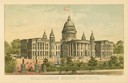
| Date: | 1891 |
|---|---|
| Description: | Chromolithograph of the third Wisconsin State Capitol with a U.S. flag atop the dome. The colored illustration was produced by the Milwaukee Lithography an... |

| Date: | 1861 |
|---|---|
| Description: | Drawn the first year of the Civil War, this colored 1861 map of Dane County shows its towns, cities and lakes. It includes insets of the wards of Madison a... |

| Date: | 03 1892 |
|---|---|
| Description: | Detail map including West Washington Avenue, West Main Street, West Wilson Street, and North and South Bedford Streets. Includes the Chicago, Milwaukee & S... |

| Date: | 1836 |
|---|---|
| Description: | Map of all Dane County and eastern towns. |

| Date: | 1839 |
|---|---|
| Description: | This map shows the hydrology of Madison and its vicinity at the height of interest in a proposed Milwaukee and Rock River Canal. It was made by Thomas Jeff... |

| Date: | 1839 |
|---|---|
| Description: | A map of the Wiskonsin [sic] and Neenah or Fox Rivers. |
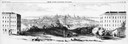
| Date: | 1858 |
|---|---|
| Description: | Panoramic sketch of State Street between North and South Halls on the University of Wisconsin-Madison campus. Published in Frank Leslie's Illustrate Newsp... |

| Date: | 07 17 1857 |
|---|---|
| Description: | A stock certificate of the Watertown and Madison Railroad Company, one share #85, issued to Darwin Clark for the sum of $50.00. This was signed by the rail... |
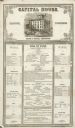
| Date: | 12 02 1855 |
|---|---|
| Description: | The Capital House bill of fare for Sunday, December 2, 1855. Proprietors were Nelson & Russell. |

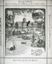
| Date: | 1867 |
|---|---|
| Description: | Bird's-eye map of Madison with insets of the University, Rasdall House, Vilas House, and the Wisconsin State Capitol. View includes cattail marsh, smokesta... |

| Date: | 1885 |
|---|---|
| Description: | Bird's-eye map of Madison, State Capital of Wisconsin, County Seat of Dane County, with inset of the Wisconsin State Capitol. |
| Date: | 1890 |
|---|---|
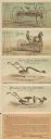
| Description: | Foldout cards in a 10-page brochure for Fuller & Johnson Mfg. Co., Ltd., manufacturers of farm implements, based in Madison, WI. The top illustration is fo... |

| Date: | 1836 |
|---|---|
| Description: | The top map is the "Plat of Madison the Capitol of Wisconsin." The bottom map is the "Map of the Four Lake Country. Taken from the Township Maps in the U.S... |

| Date: | 1889 |
|---|---|
| Description: | Illustration of the exterior of the Fuller Opera House, which is a detail from a bird's-eye view map of Madison. |

| Date: | 1870 |
|---|---|
| Description: | Bird's-eye map of Madison. The Lakeside House resort is in the foreground, which burned in 1877, in what is now Olin Park. |
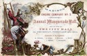
| Date: | 02 04 1864 |
|---|---|
| Description: | Embossed invitation to the fourth masquerade ball of the Madison Fire Engine Company #2. The invitation depicts a fire fighter on a ladder carrying a woman... |
If you didn't find the material you searched for, our Library Reference Staff can help.
Call our reference desk at 608-264-6535 or email us at: