 Filter: Categories of Wisconsin Historical Images
Filter: FORMAT_TYPE of prints, photomechanical
Filter: Community of Madison
Filter: Subject of water
Filter: Categories of Wisconsin Historical Images
Filter: FORMAT_TYPE of prints, photomechanical
Filter: Community of Madison
Filter: Subject of water

| Date: | 1855 |
|---|---|
| Description: | Bird's-eye view of Madison. "Taken from the Water Cure, South Side of Lake Monona, 1855." |

| Date: | 1908 |
|---|---|
| Description: | Colored map showing a panoramic view of Madison in great detail. The Wisconsin State Capitol is located at the center, with Lake Mendota in the background ... |

| Date: | 1884 |
|---|---|
| Description: | A sign for Fauerbach's Brewery depicting a young woman and the brewery. |
| Date: | 1883 |
|---|---|
| Description: | Tonyawatha Spring Hotel from a descriptive brochure. The hotel opened in 1879 and was destroyed by fire on July 31, 1895. |
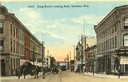
| Date: | 1910 |
|---|---|
| Description: | Colorized view of King Street, looking east, with a streetcar. Lake Monona is in the background. Caption reads: "King Street, looking East, Madison, Wis." |

| Date: | 1861 |
|---|---|
| Description: | Drawn the first year of the Civil War, this colored 1861 map of Dane County shows its towns, cities and lakes. It includes insets of the wards of Madison a... |

| Date: | 1910 |
|---|---|
| Description: | Map of Dane County rural delivery in Madison and the town of Westport. |

| Date: | 1839 |
|---|---|
| Description: | This map shows the hydrology of Madison and its vicinity at the height of interest in a proposed Milwaukee and Rock River Canal. It was made by Thomas Jeff... |

| Date: | 1839 |
|---|---|
| Description: | A map of the Wiskonsin [sic] and Neenah or Fox Rivers. |

| Date: | 1910 |
|---|---|
| Description: | Map of the general plan of the district of the Four Lakes. |
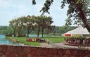
| Date: | |
|---|---|
| Description: | View from a stone bridge towards Vilas Park, with children riding the carousel (merry-go-round) and a kiddie train adjacent to the lagoon. |
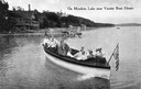
| Date: | 1915 |
|---|---|
| Description: | View of a group of people in a large model launch with an American flag. Caption reads: "On Mendota Lake near University of Wisconsin-Madison Boat House." |

| Date: | 1867 |
|---|---|
| Description: | Bird's-eye map of Madison with insets of the University, Rasdall House, Vilas House, and the Wisconsin State Capitol. View includes cattail marsh, smokesta... |

| Date: | 1885 |
|---|---|
| Description: | Bird's-eye map of Madison, State Capital of Wisconsin, County Seat of Dane County, with inset of the Wisconsin State Capitol. |

| Date: | 1836 |
|---|---|
| Description: | The top map is the "Plat of Madison the Capitol of Wisconsin." The bottom map is the "Map of the Four Lake Country. Taken from the Township Maps in the U.S... |

| Date: | 1870 |
|---|---|
| Description: | Bird's-eye map of Madison. The Lakeside House resort is in the foreground, which burned in 1877, in what is now Olin Park. |

| Date: | 1949 |
|---|---|
| Description: | Color bird's-eye map of the University of Wisconsin-Madison as it was midcentury, with two co-eds, several photographs of campus landmarks around edges, an... |

| Date: | 1929 |
|---|---|
| Description: | Bird's-eye map of the University of Wisconsin-Madison on Lake Mendota. Black and white drawing with named streets and numbered buildings without location ... |
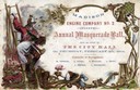
| Date: | 02 04 1864 |
|---|---|
| Description: | Embossed invitation to the fourth masquerade ball of the Madison Fire Engine Company #2. The invitation depicts a fire fighter on a ladder carrying a woman... |

| Date: | 1855 |
|---|---|
| Description: | Part of George Harrison's "Map of the City of Madison," showing the development of the isthmus and the small size of the second Capitol (54' x 104') in com... |
If you didn't find the material you searched for, our Library Reference Staff can help.
Call our reference desk at 608-264-6535 or email us at: