Filter: Categories of Wisconsin Historical Images
Filter: FORMAT_TYPE of prints, photomechanical
Filter: Type of Map or Atlas
Filter: Categories of Wisconsin Historical Images
Filter: FORMAT_TYPE of prints, photomechanical
Filter: Type of Map or Atlas
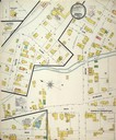
| Date: | 10 1914 |
|---|---|
| Description: | Page 2 of a Sanborn-Perris map of Pewaukee. |
| Date: | 07 1924 |
|---|---|
| Description: | Page 3 of Sanborn-Perris map of Pewaukee. |
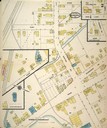
| Date: | 11 1899 |
|---|---|
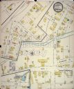
| Description: | Page 1 of Sanborn-Perris map of Pewaukee. |
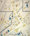
| Date: | 10 1894 |
|---|---|
| Description: | Page 1 of Sanborn-Perris map of Pewaukee. |

| Date: | 1632 |
|---|---|
| Description: | The Wisconsin portion of Champlain's 1632 map, augmented since the previous one, for navigation according to the true Meridien, by Sieur de Champlain. The ... |

| Date: | 1918 |
|---|---|
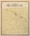
| Description: | Page from the Standard Atlas of Grant County, Wisconsin of Part of Townships 5 and 6 North, Range 5 West of the 4th P.M. |

| Date: | 1892 |
|---|---|
| Description: | Bird's-eye view of the Columbian Exposition pavilions from the vantage point of Lake Michigan. Included is an inset of the Union Passenger Station (now Uni... |
| Date: | 1897 |
|---|---|
| Description: | Plat Map of Glendale Township in Monroe County. |

| Date: | 1950 |
|---|---|
| Description: | Map showing buildings formerly used as Ringling Brothers Circus winter quarters, along with adjoining buildings. |
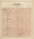
| Date: | 1861 |
|---|---|
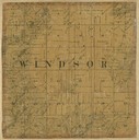
| Description: | Dane County plat map of the town of Windsor. |

| Date: | 1867 |
|---|---|
| Description: | Drawn map showing planned development of Cornell, including a couple of schools, Oakwood cemetery, the public square, and several bridges and dams. |

| Date: | 1856 |
|---|---|
| Description: | Wisconsin map illustrating the Mineral Point Railroad and its connections. |

| Date: | 1911 |
|---|---|
| Description: | Plat Map of Blooming Grove in "Atlas of Dane County, Wisconsin." |

| Date: | 1814 |
|---|---|
| Description: | Map of the Upper Territories of the United States. |

| Date: | 1879 |
|---|---|
| Description: | Bird's-eye view drawing of various buildings on the University of Wisconsin-Madison. Buildings include: Ladies Hall, South Dormitory, University Hall, Asse... |

| Date: | 1832 |
|---|---|
| Description: | Route of Military Road from Fort Crawford to Fort Howard. Map shows beginning of route at Fort Crawford. |

| Date: | 05 1926 |
|---|---|
| Description: | Section 1 of a Sanborn map of Osceola. |
If you didn't find the material you searched for, our Library Reference Staff can help.
Call our reference desk at 608-264-6535 or email us at: