 Filter: Categories of Wisconsin Historical Images
Filter: FORMAT_TYPE of prints, fine-art
Filter: Year of 1800-1899
Filter: Type of Drawing
Filter: Categories of Wisconsin Historical Images
Filter: FORMAT_TYPE of prints, fine-art
Filter: Year of 1800-1899
Filter: Type of Drawing
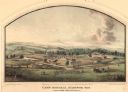
| Date: | 05 1864 |
|---|---|
| Description: | Lithograph of Camp Randall, where the majority of Wisconsin's soldiers were trained and mustered into the Union Army. This view, which was taken from Basc... |
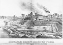
| Date: | 1880 |
|---|---|
| Description: | Lithograph of the Milwaukee Cement Company's Works at 154 West Water Street in Milwaukee. |
| Date: | 1850 |
|---|---|
| Description: | Chippewa Indian Sugar Camp. Plate 61, preceding p. 199, vol. I, The Indian tribes of the United States: their history antiquities, customs, religion, ar... |
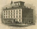
| Date: | 1853 |
|---|---|
| Description: | Illustration of the Capital house, a first-class hotel, copied from page 320 of Gleason's Pictorial Drawing-Room Companion. |

| Date: | 1848 |
|---|---|
| Description: | The first Fort Crawford at Prairie du Chien, with the Mississippi River in the foreground. Although dated 1830, this scene was actually painted by Henry Le... |

| Date: | 1854 |
|---|---|
| Description: | Drawing of the Porcupine Mountains on Lake Superior. A deer is standing in the lake drinking water. A man is on the rock ledge above the shoreline and is a... |
| Date: | 1850 |
|---|---|
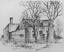
| Description: | Strang House, also called "Mormon House," where "King" Strang lived and died, and where he published the Voree Herald. |
| Date: | 12 01 1851 |
|---|---|
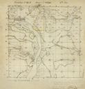
| Description: | Plat map of Wisconsin township 12, North, 9E. |
| Date: | 1895 |
|---|---|
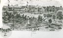
| Description: | View of the Tonyawatha Spring Hotel grounds, located on Lake Monona in Blooming Grove Township, just outside of Madison. The hotel opened in 1879 and on Ju... |
| Date: | 1879 |
|---|---|
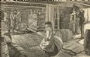
| Description: | Drawing of a girl sitting on a barrel as a man dumps apples into a press to make cider. Two men manually operate the press at the left. |
| Date: | 1855 |
|---|---|
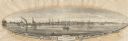
| Description: | View of Detroit with several boats and ships in (probably) the Detroit River. |

| Date: | 1837 |
|---|---|
| Description: | Copy of N.F. Hyer's original map of Aztalan as published in the Milwaukee Advertiser, February 25, 1837. |

| Date: | 1860 |
|---|---|
| Description: | Two hands shaking with the Constitution, Union flag, battle ax and stars in the background. Caption below reads, "Our Union Forever." Red and blue ink on b... |
| Date: | 1815 |
|---|---|
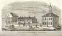
| Description: | Engraved view of the first state buildings in Columbus, Ohio, including the United States Courthouse, Public Offices and the Old State House. A number of p... |
If you didn't find the material you searched for, our Library Reference Staff can help.
Call our reference desk at 608-264-6535 or email us at: