 Filter: Categories of Wisconsin Historical Images
Filter: FORMAT_TYPE of prints, fine-art
Filter: Subject of ships
Filter: Categories of Wisconsin Historical Images
Filter: FORMAT_TYPE of prints, fine-art
Filter: Subject of ships

| Date: | 02 21 1882 |
|---|---|
| Description: | Chromolithograph poster advertising a Milwaukee Mardi Gras celebration, arranged by the Turnverein and Milwaukee Musical Societies, and held at the Exposit... |
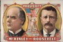
| Date: | 1899 |
|---|---|
| Description: | Campaign poster with the title "Posterity" for Theodore Roosevelt and William McKinley featuring their portraits. In the center is an illustration of a wom... |

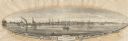
| Date: | 1886 |
|---|---|
| Description: | Bird's-eye view of Milwaukee from Bay View. |

| Date: | |
|---|---|
| Description: | Looking West from Knight Block, with shipping piers and sailing ships on right side, railroad on left, trees in background. Horse-drawn carriages on street... |
| Date: | 1855 |
|---|---|
| Description: | View of Detroit with several boats and ships in (probably) the Detroit River. |

| Date: | 1930 |
|---|---|
| Description: | An original lithograph depicting a scene aboard a United States Lines passenger ship, featuring what appears to be the New York City skyline in the backgro... |

| Date: | 1930 |
|---|---|
| Description: | An original lithograph depicting a scene aboard a United States Lines passenger ship, featuring a man and a woman looking toward the ocean's horizon. |
| Date: | 1947 |
|---|---|
| Description: | An original lithograph promoting New York Central Lines railway and the area of New England, deemed "America's Historic Summerland" in the poster. Featurin... |
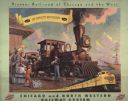
| Date: | 1948 |
|---|---|
| Description: | An original colored lithograph advertising the Chicago and North Western Railway's 100th Anniversary from 1848 to 1948. The poster features the artist Paul... |

| Date: | 1922 |
|---|---|
| Description: | An original colored lithograph advertising the Virginia Historical Pageant, held in Richmond, VA, May 22-28, 1922. Featuring the Henry Day Lowry Metropolit... |

| Date: | |
|---|---|
| Description: | A large lithograph of the most immediate of the tragic results of the civil war in Mobile, Alabama, which was the great explosion of May 25, 1865. Federal ... |
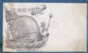
| Date: | 1860 |
|---|---|
| Description: | A Union sailor and King Neptune stand inside a sea shell that is floating on the ocean. Between them appears a decorative circle with the Union Armada in i... |
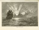
| Date: | 1874 |
|---|---|
| Description: | Engaved view depicting a dramatic sunset through clouds over Lake Michigan. Several sailing ships are in the foreground. |

| Date: | 1874 |
|---|---|
| Description: | Engraved view of downtown Racine seen from Lake Michigan. Several vessels are entering the harbor, and a pier with a beacon is on the right. |

| Date: | 1941 |
|---|---|
| Description: | Elevated view of Sturgeon Bay in 1900. Sturgeon Bay Bridge spans the bay and several boats are on the water. A lighthouse sits on a small island in the bay... |

| Date: | 1935 |
|---|---|
| Description: | This blue lined map shows the major roads and cities of Wisconsin. The map includes an index, hotel and cafe advertisements, as well as advertisements for ... |

| Date: | 1935 |
|---|---|
| Description: | This blue lined map ("compliments of Black Eagle Oil Company") shows the major roads and cities of Wisconsin. The map includes an index, hotel and cafe adv... |

| Date: | 1872 |
|---|---|
| Description: | This map includes depth shown by soundings and isolines and relief shown by contours. Tree species and locations are labeled, as well as a cranberry meadow... |

| Date: | 1750 |
|---|---|
| Description: | Map of the northeast corner of America and Canada with hand-colored boundaries. The map shows colonies, Native American nations, fishing areas, and detaile... |

| Date: | 1783 |
|---|---|
| Description: | This map is hand-colored and shows the boundaries of British, Spanish, and the newly recognized American claims, as well as the fishing rights granted to F... |
If you didn't find the material you searched for, our Library Reference Staff can help.
Call our reference desk at 608-264-6535 or email us at: