 Filter: Categories of Wisconsin Historical Images
Filter: FORMAT_TYPE of prints, fine-art
Filter: Subject of mississippi river
Filter: Categories of Wisconsin Historical Images
Filter: FORMAT_TYPE of prints, fine-art
Filter: Subject of mississippi river

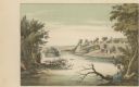
| Date: | 1848 |
|---|---|
| Description: | The first Fort Crawford at Prairie du Chien, with the Mississippi River in the foreground. Although dated 1830, this scene was actually painted by Henry Le... |

| Date: | 1829 |
|---|---|
| Description: | Hand-colored lithograph of Fort Armstrong on Rock Island, based on a drawing by Henry Lewis. Foreground shows a tree floating in the water. |

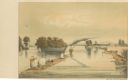
| Date: | 1829 |
|---|---|
| Description: | Hand-colored lithograph of Fort Armstrong, based on a drawing by Henry Lewis. Includes boats on the Mississippi River. |
| Date: | |
|---|---|
| Description: | Drawing of St. Paul, Minnesota, depicting a small town on a hillside overlooking the Mississippi River. A Native American sits on a log in the foreground. ... |
| Date: | |
|---|---|
| Description: | Lithographed drawing of the mouth of the St. Croix River depicting a sailing barge and steamboat in the distance. Print is part of a series collected in Le... |
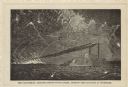
| Date: | |
|---|---|
| Description: | A woodcut of "The Carondelet, leading Logan's supply fleet, running the blockade at Vicksburg." |
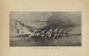
| Date: | |
|---|---|
| Description: | A halftone lithograph of the Battle of Grand Gulf, Mississippi. |
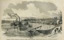
| Date: | 05 31 1862 |
|---|---|
| Description: | Engraved view of the Commisary [sic] depot of Major-General Halleck's army at Hamburg Landing. |

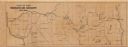
| Date: | 1835 |
|---|---|
| Description: | Plat for a proposed Sinsinawa City (never built), in Grant County, Wis. When it became clear in the mid-1830s that Wisconsin Territory would be established... |

| Date: | 02 1823 |
|---|---|
| Description: | A map featuring the North American expedition from Pittsburgh to the Rocky Mountains led by Edwin James. |
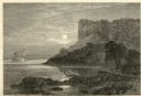
| Date: | 1874 |
|---|---|
| Description: | Engraved view of Maiden's Rock at Lake Pepin. A steamboat is on the Mississippi River. |

| Date: | 1950 |
|---|---|
| Description: | This map is intended for tourists visiting La Crosse. The front of the map provides extensive text on attractions and activities in La Crosse while the bac... |

| Date: | 1975 |
|---|---|
| Description: | This map provides an index of outdated quadrangle maps for the state. Communities, counties, rivers, and lakes are labeled including Lake Michigan and Lake... |

| Date: | 1937 |
|---|---|
| Description: | Pictorial map showing historical events and locations within the state of Wisconsin, as well as waterways and counties. Original caption on the bottom marg... |
| Date: | 1850 |
|---|---|
| Description: | This map shows a cross-section of southern Wisconsin, with the Milwaukee and Mississippi Railroad line running from Milwaukee to the Mississippi River near... |

| Date: | 1853 |
|---|---|
| Description: | Map of a cross-section of southern Wisconsin, highlighting the La Crosse Milwaukee Rail Road. Shows canals, railroads, plank and post roads, and township g... |

| Date: | 1900 |
|---|---|
| Description: | This map shows the boundary lines between ceded and unceded land in compliance with the Treaty of Prairie du Chen of 1829. It also shows roads, rivers, por... |

| Date: | 1829 |
|---|---|
| Description: | This map shows waterways, trails, settlements, Indian villages, and boundaries. The map includes text in the lower left with excerpts from Indian land trea... |

| Date: | 1855 |
|---|---|
| Description: | This map shows current and purposed railroad routes. Lake Michigan is on the far right, with Lake Superior visible at the top of the map. Routes are marked... |

| Date: | 1856 |
|---|---|
| Description: | This map shows the railroad routes and connection of the Mineral Point Railroad. Lake Michigan is on the far right, while Lake Superior is at the top of th... |
If you didn't find the material you searched for, our Library Reference Staff can help.
Call our reference desk at 608-264-6535 or email us at: