 Filter: Categories of Wisconsin Historical Images
Filter: FORMAT_TYPE of prints, fine-art
Filter: Subject of intellectual life
Filter: Subject of birds
Filter: Categories of Wisconsin Historical Images
Filter: FORMAT_TYPE of prints, fine-art
Filter: Subject of intellectual life
Filter: Subject of birds
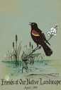
| Date: | 1972 |
|---|---|
| Description: | Cover for the Wisconsin Friends of Our Native Landscape program. Depicted is a red wing blackbird perching on cattail flowers in a body of water. The Wisco... |
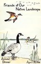
| Date: | 1968 |
|---|---|
| Description: | Cover for the Wisconsin Friends of Our Native Landscape program. Depicted are two geese and a duck on a lake. The Wisconsin Friends chapter was founded in ... |
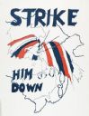
| Date: | 02 1971 |
|---|---|
| Description: | Political propaganda poster featuring a red, white, and blue eagle being struck down from the sky, accompanied by the phrase: "Strike Him Down." The eagle... |
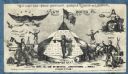
| Date: | 1860 |
|---|---|
| Description: | Text at top reads, "CHAMPION PRIZE ENVELOPE - LINCOLN & DAVIS IN 5 ROUNDS," underneath reads "5TH ROUND." Lincoln stands inside "THE CHAMPION BELT" beside ... |
| Date: | 1860 |
|---|---|
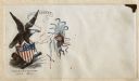
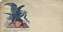
| Description: | The American Eagle is holding a banner with the word "BEWARE" on it in his beak. He is gripping a federal shield with a Union flag draped over it with his ... |
| Date: | 1860 |
|---|---|
| Description: | An owl labeled "SCOTT" seizes a vulture labeled "JEFF DAVIS" by the wing. Feathers litter the ground beneath them. The owl is saying "LET YOU ALONE AND YOU... |
| Date: | 1949 |
|---|---|
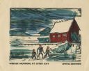
| Description: | Holiday card of the Sister Bay lakeshore. Three figures are on the shore. Two boathouses, a covered boat, a pier, and two upright boats are in the backgrou... |

| Date: | 1958 |
|---|---|
| Description: | This map shows state public hunting and/or fishing grounds, national forests, state forests, county forests.The lower margin includes an index to these loc... |

| Date: | 1746 |
|---|---|
| Description: | This world map from the German mathematician, historian, and geographer Johann Matthias Hase shows the major cities, islands, and the major political divis... |

| Date: | 1685 |
|---|---|
| Description: | A detailed map of the western hemisphere showing cities, settlements, Native American land, rivers, lakes, mountains, the Great Lakes, and California as an... |

| Date: | 1746 |
|---|---|
| Description: | Detailed map of the western hemisphere and part of Africa and Europe. Islands, cities, settlements, rivers, lakes, countries, and regions are marked. Mount... |

| Date: | 1719 |
|---|---|
| Description: | Map of North America showing land divisions between France, Spain, England, Sweden, Denmark and Holland. The map is detailed, labeling cities, forts, islan... |

| Date: | 1766 |
|---|---|
| Description: | This map of North America shows the boundaries of European claims at the end of the French and Indian war. The British colonies extend to the Mississippi. ... |

| Date: | 1758 |
|---|---|
| Description: | Map showing lakes, rivers, cities, Native American land, and the boundaries of French and English claims in America and Canada north of New York. A title c... |

| Date: | 1720 |
|---|---|
| Description: | Detailed, ornate, and comprehensive map of America from the east coast to present day Texas. Numerous features appear throughout the map, including Native ... |

| Date: | |
|---|---|
| Description: | Letterhead on blue paper of an eagle holding arrows, sitting on top of a rock next to the American flag. Text printed on the rock reads: "The Constitution ... |
| Date: | |
|---|---|
| Description: | Letterhead of a bald eagle perched on a shield, and holding a banner of stars in its beak. Words printed under the image read: "The laws must be obeyed; th... |
| Date: | |
|---|---|
| Description: | Letterhead of an eagle sitting on a rock. The American flag is on the right, and the first Confederate flag, which is tattered and being struck by lightnin... |

| Date: | 03 28 1862 |
|---|---|
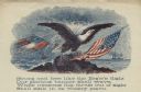
| Description: | Letterhead with a bald eagle carrying the American flag with its talons. The text above the eagle reads: "Union & Liberty." 4 page, folded, printed in red ... |
If you didn't find the material you searched for, our Library Reference Staff can help.
Call our reference desk at 608-264-6535 or email us at: