 Filter: Categories of Wisconsin Historical Images
Filter: FORMAT_TYPE of prints, fine-art
Filter: Subject of human settlements
Filter: Year of 1800-1899
Filter: Categories of Wisconsin Historical Images
Filter: FORMAT_TYPE of prints, fine-art
Filter: Subject of human settlements
Filter: Year of 1800-1899
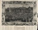
| Date: | 1890 |
|---|---|
| Description: | Depiction of the National Encampment of the Grand Army of the Republic, held in Boston, Massachusetts. On the border surrounding the group portrait are ind... |
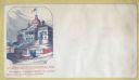
| Date: | 1861 |
|---|---|
| Description: | The State House of Massachusetts in Boston with the Union flag flying over it. Men and women walk in front of it. The caption below reads, "No traitor's fl... |
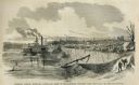
| Date: | 05 31 1862 |
|---|---|
| Description: | Engraved view of the Commisary [sic] depot of Major-General Halleck's army at Hamburg Landing. |
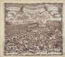
| Date: | 1819 |
|---|---|
| Description: | A commemorative handkerchief created by a wood engraving on white cotton fabric. The scene is the Manchester Reform Meeting, in England. A crowd of demonst... |

| Date: | 1865 |
|---|---|
| Description: | This pen and ink map sketches the route taken by General Sherman's troops from Atlanta, Georgia, to Savannah, Georgia. Railroads, rivers, and towns are lab... |
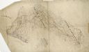
| Date: | 1864 |
|---|---|
| Description: | This pen and ink tracing illustrates the route traveled by Sherman's troops through Georgia, South Carolina, and North Carolina in the winter and spring of... |

| Date: | 1835 |
|---|---|
| Description: | Plat for a proposed Sinsinawa City (never built), in Grant County, Wis. When it became clear in the mid-1830s that Wisconsin Territory would be established... |

| Date: | 1874 |
|---|---|
| Description: | Engraved view of downtown Racine seen from Lake Michigan. Several vessels are entering the harbor, and a pier with a beacon is on the right. |
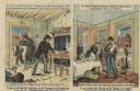
| Date: | 1884 |
|---|---|
| Description: | Political cartoon comparing the Democratic Platform with the Republican Platform. The cartoon (Democratic) on the left depicts a poor family wearing rags i... |

| Date: | 1898 |
|---|---|
| Description: | This 1898 map of Sawyer County, Wisconsin, shows the township and range system, sections, roads, farm houses, camps, school houses, dams, bridges, Indian r... |
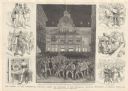
| Date: | 06 03 1884 |
|---|---|
| Description: | Illustrations=s of the Republican National Convention. The main drawing shows an outside view with the caption "Scene in front of the convention building d... |

| Date: | 1854 |
|---|---|
| Description: | Register of the Deed Office filed by the land surveyor and lawyer Alfred Topliff. The document includes detailed listings of city blocks. In the right hand... |

| Date: | 1873 |
|---|---|
| Description: | Map shows townships and sections, landownership and acreages, state and county lands, churches, schools, cemeteries, roads, and railroads. There is an inse... |

| Date: | 1871 |
|---|---|
| Description: | Map created between 1871 and 1880. Shows townships, post offices, a possible railroad to Penoka Iron Range, and the North Wisconsin Railroad. |
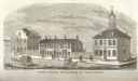
| Date: | 1815 |
|---|---|
| Description: | Engraved view of the first state buildings in Columbus, Ohio, including the United States Courthouse, Public Offices and the Old State House. A number of p... |

| Date: | 1861 |
|---|---|
| Description: | The township of Primrose, which is a detail from the plat map of Dane County. |

| Date: | 1861 |
|---|---|
| Description: | The township of Montrose, which is a detail from a Dane County plat map. |

| Date: | 05 1854 |
|---|---|
| Description: | This yellow and black wood block print broadside ties England and France's declaration of war against Russia during the Crimean War into a war against high... |

| Date: | 01 01 1856 |
|---|---|
| Description: | This map is mounted on cloth and shows lots, as well as location of the public square and college. Streets are labeled as is the Wisconsin River. |
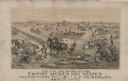
| Date: | 1893 |
|---|---|
| Description: | Lithograph of the Empire Mower and Reaper; several other reaper manufacturers and models are identified in the illustration which appears above the text: “... |
If you didn't find the material you searched for, our Library Reference Staff can help.
Call our reference desk at 608-264-6535 or email us at: