 Filter: Categories of Wisconsin Historical Images
Filter: FORMAT_TYPE of prints, fine-art
Filter: Subject of great lakes
Filter: Categories of Wisconsin Historical Images
Filter: FORMAT_TYPE of prints, fine-art
Filter: Subject of great lakes
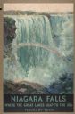
| Date: | 1934 |
|---|---|
| Description: | An original lithograph promoting Niagara Falls as the place "Where the Great Lakes Leap to the Sea, Travel by Train." Featuring the artist Fredric C. Madan... |

| Date: | 1695 |
|---|---|
| Description: | Copperplate engraving; Venice, 1695. Scale [ca. 1:5,069,000] at center. |

| Date: | 1688 |
|---|---|
| Description: | This map includes vignettes of Amerindian life with text describing geography, culture, and exploration activity, written in French. The Great Lakes, river... |

| Date: | 1778 |
|---|---|
| Description: | Hand-colored. London, 1778. Coordinates: W 99⁰--W 83⁰/N 49⁰--N 41⁰. Scale [ca. 1:3,500,000] |

| Date: | 02 1823 |
|---|---|
| Description: | A map featuring the North American expedition from Pittsburgh to the Rocky Mountains led by Edwin James. |

| Date: | 1785 |
|---|---|
| Description: | Map of part of North America engraved and hand-colored (the light brown design is a superposition of the map and cartouche derived from the oxidation of th... |

| Date: | 02 01 1793 |
|---|---|
| Description: | Text in the upper right corner reads, "A Map of The Western Part of the Territories belonging to the United States of America. Drawn from the best authorit... |

| Date: | 1975 |
|---|---|
| Description: | This map provides an index of outdated quadrangle maps for the state. Communities, counties, rivers, and lakes are labeled including Lake Michigan and Lake... |

| Date: | 1936 |
|---|---|
| Description: | This map shows road surfaces, construction, flying fields, seaplane landings, populations of cities and towns, and ferry routes of Wisconsin and some of th... |

| Date: | 1937 |
|---|---|
| Description: | This map shows the major roads, cities, towns, lakes, and rivers of Wisconsin and some of the neighboring states. The front includes an add for Coca-Cola, ... |

| Date: | 1937 |
|---|---|
| Description: | This map shows the major cities, towns, highways, roads, lakes, and rivers of Wisconsin and some of the neighboring states. An index is included on the fro... |

| Date: | 1881 |
|---|---|
| Description: | This map shows railroads, county boundaries, cities, towns, and waterways with relief shown by hachures. The prime meridians are: Greenwich and Washington.... |

| Date: | 1887 |
|---|---|
| Description: | This map shows railroads, county boundaries, cities, towns, and waterways with relief shown by hachures. The prime meridians are: Greenwich and Washington.... |

| Date: | 1872 |
|---|---|
| Description: | This map includes depth shown by soundings and isolines and relief shown by contours. Tree species and locations are labeled, as well as a cranberry meadow... |

| Date: | 1710 |
|---|---|
| Description: | A seminal and fairly accurate map of the Great Lakes Region up to Baffin's Bay in Northern Canada. This is possibly the first printed map to locate Detroit... |

| Date: | 1696 |
|---|---|
| Description: | This sea chart and topographical map depicts the north east coast of Canada and North America, focusing on the Hudson Bay and Great Lakes regions. It shows... |

| Date: | 1685 |
|---|---|
| Description: | A detailed map of the western hemisphere showing cities, settlements, Native American land, rivers, lakes, mountains, the Great Lakes, and California as an... |

| Date: | 1709 |
|---|---|
| Description: | Map of North America, showing a few of the largest settlements, regions, islands, and a few rivers. The Great Lakes are depicted, but over-sized, and Calif... |

| Date: | 1719 |
|---|---|
| Description: | Map of the Great Lakes and the St. Lawrence river showing French and English cities and villages, trading posts, Indian villages and tribes, portages, for... |

| Date: | 1766 |
|---|---|
| Description: | Map of the north western hemisphere using sinusoidal projection to show the curvature of the earth. It labels regions, cities, Native American land, island... |
If you didn't find the material you searched for, our Library Reference Staff can help.
Call our reference desk at 608-264-6535 or email us at: