 Filter: Categories of Wisconsin Historical Images
Filter: FORMAT_TYPE of prints, fine-art
Filter: Subject of governors
Filter: Categories of Wisconsin Historical Images
Filter: FORMAT_TYPE of prints, fine-art
Filter: Subject of governors
| Date: | 09 1825 |
|---|---|
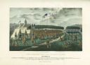
| Description: | Treaty at Prairie du Chien, with Fort Crawford seen in the background. This treaty negotiated between Governor William Clark and Governor Lewis Cass and ov... |

| Date: | 1835 |
|---|---|
| Description: | Little Lake Butte Des Morts just north of Lake Winnebago where Governor Lewis Cass of Michigan, and Thomas McKenney, head of the Bureau of Indian Affairs (... |

| Date: | 1865 |
|---|---|
| Description: | Engraved portrait of Wisconsin Governor James Lewis. Lewis' signature is below the engraving, and underneath the signature is printed: "Governor of Wiscons... |
| Date: | 11 08 1938 |
|---|---|
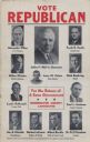
| Description: | Political poster urging voters to elect Republican candidates. Each candidate appears with a quarter-length portrait. Text at the top, "Vote Republican." I... |

| Date: | 03 08 |
|---|---|
| Description: | Artwork by Steve H--. Silkscreen. Governor Lee Sherman Dreyfus quote illustrated "I Eat Bee Poop." "Wisconsin Grade A Fancy" in lower left corner. Presen... |
| Date: | 1876 |
|---|---|
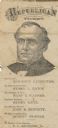
| Description: | Republican ticket for Harrison Ludington for governor, Henry L. Eaton for Lieutenant-Governor, Hans B. Warner for Secretary of State, Henry Baetz for State... |
| Date: | |
|---|---|
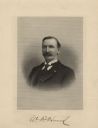
| Description: | Quarter-length engraved portrait of William D. Hoard. He is wearing a suit and tie, and has a full moustache and a slight beard. Hoard's signature is repro... |
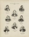
| Date: | 1878 |
|---|---|
| Description: | This print shows eight former Governors of Wisconsin. In date order: "Louis P. Harvey, 1862 til April 20"; "Edward Salomon, April 20 1862-1864"; "James T. ... |

| Date: | 1760 |
|---|---|
| Description: | Map showing the towns, mountains, valleys, corn fields, and rivers of a portion of the Cherokee Nation. A few annotations on the map explain the land and r... |
If you didn't find the material you searched for, our Library Reference Staff can help.
Call our reference desk at 608-264-6535 or email us at: