 Filter: Categories of Wisconsin Historical Images
Filter: FORMAT_TYPE of prints, fine-art
Filter: Subject of farms
Filter: Categories of Wisconsin Historical Images
Filter: FORMAT_TYPE of prints, fine-art
Filter: Subject of farms

| Date: | 03 24 1913 |
|---|---|
| Description: | Picnic Point from the University Farm fields, now known as Observatory Hill. |
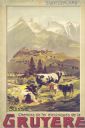
| Date: | 1900 |
|---|---|
| Description: | An original colored lithograph advertising the Chemins de fer électriques de la Gruyèr railway in Switzerland. The poster features the artist Anton Reckzi... |
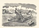
| Date: | 1877 |
|---|---|
| Description: | Letterpress print of McCormick's Harvester and Self Binder (wire binder). The grain binder is operated by a man seated on the machine and pulled by two hor... |

| Date: | |
|---|---|
| Description: | Letterpress print of a McCormick Harvester & Twine Binder. The grain binder is operated by a man seated on the machine and pulled by two horses. A farmhous... |

| Date: | 1898 |
|---|---|
| Description: | This 1898 map of Sawyer County, Wisconsin, shows the township and range system, sections, roads, farm houses, camps, school houses, dams, bridges, Indian r... |

| Date: | 1913 |
|---|---|
| Description: | This photocopy map shows plots with owners' names, land use both commercial and agricultural, and lot outlines on University land. Lake Mendota is labeled ... |

| Date: | 1775 |
|---|---|
| Description: | Map of Boston and surrounding regions, from Massachusetts Bay to the Connecticut River, and including part of southern New Hampshire. It shows the colonies... |

| Date: | 03 1777 |
|---|---|
| Description: | Map showing the British and Hessian attack on Fort Washington in November of 1776. The movements and fortifications of the British and Hessian troops appea... |

| Date: | 1776 |
|---|---|
| Description: | Fairly detailed map of New York City and parts of Long Island. It shows streets, roads, wharves, ferries, ship yards, Fort George and the battery, public b... |
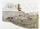
| Date: | |
|---|---|
| Description: | Pen and ink drawing farm scene of a man digging in a small, fenced-in plot of bare earth land. The scene includes two cows, two birds, a haystack, windmill... |
If you didn't find the material you searched for, our Library Reference Staff can help.
Call our reference desk at 608-264-6535 or email us at: