 Filter: Categories of Wisconsin Historical Images
Filter: FORMAT_TYPE of prints, fine-art
Filter: Subject of education
Filter: Categories of Wisconsin Historical Images
Filter: FORMAT_TYPE of prints, fine-art
Filter: Subject of education

| Date: | 02 1971 |
|---|---|
| Description: | Screen printed poster announcing a performance by Miles Davis Quintet and Keith Jarrett, occurring Thursday, March 18, 1971, at the Union Theater in the Un... |
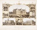
| Date: | 1867 |
|---|---|
| Description: | 1868-1875. Founded by Dr. Joseph Salzman (featured in the vignette at left, teaching). Vignette, lower left, features St. Francis Seminary, founded in 1856... |

| Date: | 12 1971 |
|---|---|
| Description: | Poster announcing an all-student outdoor sculpture competition, sponsored by the Wisconsin Union for University of Wisconsin-Madison students. Features a t... |
| Date: | 07 1973 |
|---|---|
| Description: | Print publicizing an art exhibition by University of Wisconsin-Madison student MFA candidate S. Price. A woodblock print of an image of a man bending over,... |

| Date: | 11 1970 |
|---|---|
| Description: | Poster advertising a lecture by Dr. Dwight Allen, the Dean of the University of Massachusetts School of Education on the Baha'i perspective of universal ed... |

| Date: | 1898 |
|---|---|
| Description: | This 1898 map of Sawyer County, Wisconsin, shows the township and range system, sections, roads, farm houses, camps, school houses, dams, bridges, Indian r... |

| Date: | 1873 |
|---|---|
| Description: | Map shows townships and sections, landownership and acreages, state and county lands, churches, schools, cemeteries, roads, and railroads. There is an inse... |
| Date: | 1900 |
|---|---|
| Description: | This advertisement features drawings of Shakespeare's Seven Ages beginning at the top left with: 'The Infant — "Perdita" Winter's Tale,' 'The Schoolboy — "... |

| Date: | 1900 |
|---|---|
| Description: | This map shows landownership, railroads, roads, churches, schools, cemeteries, post offices, townships, city wards, Lake Michigan, and rivers. The map incl... |

| Date: | 1905 |
|---|---|
| Description: | This blueprint map shows buildings and roads on Bascom Hill. University Avenue, Park street, Charter Street, and Lincoln Drive are labeled. Lake Mendota is... |

| Date: | 1902 |
|---|---|
| Description: | This map shows townships, land parcels, schools, rivers, lakes, creameries, churches, cemeteries, roads, post offices, town halls, saw mills, roads and sto... |

| Date: | 1915 |
|---|---|
| Description: | This map shows roads, railroads, street railways, abandoned logging railroads, rural mail routes, telephone lines, schools, platted land, and state forest ... |

| Date: | 1896 |
|---|---|
| Description: | This map shows railroads, churches, schools, cemeteries, rivers, lakes, and some rural property owners. |
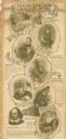
| Date: | 1878 |
|---|---|
| Description: | Six lithographs are grouped together showing mostly state normal schools. The scenes clockwise from top left are: State Normal School, Oshkosh; State Norma... |

| Date: | 1925 |
|---|---|
| Description: | This map oriented with north to the upper right and shows 14 overlapping school districts. From left to right the schools include: Randall, Longfellow, Fra... |

| Date: | 1925 |
|---|---|
| Description: | This map oriented with north to the upper right shows 12 school districts of new proposed schools and existing schools. From left to right existing schools... |

| Date: | 1889 |
|---|---|
| Description: | This map lists township and section numbers outside municipality, housing additions and subdivisions and plat owners outside municipality, the Black River,... |

| Date: | 1926 |
|---|---|
| Description: | This blueprint map is oriented with north to the upper left. The map shows buildings with note of those "to be torn down," sidewalks, proposed power plant,... |
If you didn't find the material you searched for, our Library Reference Staff can help.
Call our reference desk at 608-264-6535 or email us at: