 Filter: Categories of Wisconsin Historical Images
Filter: FORMAT_TYPE of prints, fine-art
Filter: Subject of deer
Filter: Categories of Wisconsin Historical Images
Filter: FORMAT_TYPE of prints, fine-art
Filter: Subject of deer

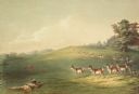
| Date: | 1854 |
|---|---|
| Description: | Drawing of the Porcupine Mountains on Lake Superior. A deer is standing in the lake drinking water. A man is on the rock ledge above the shoreline and is a... |
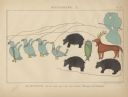
| Date: | 1844 |
|---|---|
| Description: | Indian with rifle in prone position hunting antelope (Plate 20). "The antelope of the prairies and Rocky Mountains of America, which I believe to be diff... |

| Date: | 07 1972 |
|---|---|
| Description: | Poster created by Madison-based Johnathan Chritton, most likely to commemorate the release of the album "Harvest" (1972), featuring Neil Young playing an a... |

| Date: | 1952 |
|---|---|
| Description: | This map shows lakes, rivers, railroads, highways, roads, hunting grounds and trails around Flambeau Flowage and Boulder Junction in the north, to Brantwoo... |

| Date: | 1958 |
|---|---|
| Description: | This map shows state public hunting and/or fishing grounds, national forests, state forests, county forests.The lower margin includes an index to these loc... |

| Date: | 1966 |
|---|---|
| Description: | This map shows trails, roads, creeks, alleged location of George Gardner's trading post, Boulder and Mud Lakes, and a portion of the Wolf River. The map al... |

| Date: | 1718 |
|---|---|
| Description: | This map shows the Mississippi River, with latitude and longitude coordinates, ad covers east to Lake Ontario and south to Illinois. The inset map (the top... |
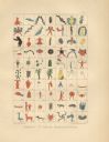
| Date: | 1851 |
|---|---|
| Description: | Synopsis of Indian Hieroglyphics. Pictographs 71-140, including birds, human figures, plants, animals and other symbols. |
| Date: | 1851 |
|---|---|
| Description: | Pictograph E., Plate 63, "Kaizheosh, and his Band from Lake Vieu Desert. Michigan and Wisconsin." A group of symbols including birds, animals, a fish and a... |

| Date: | 1746 |
|---|---|
| Description: | This world map from the German mathematician, historian, and geographer Johann Matthias Hase shows the major cities, islands, and the major political divis... |

| Date: | 1636 |
|---|---|
| Description: | Map of North America, divided into regions, and showing some rivers, lakes, settlements, cities, mountains, and Native American land. Of the Great Lakes on... |

| Date: | 1740 |
|---|---|
| Description: | Map including the regions and cities of the northern half of North America. Native American land, rivers, lakes, mountains are labeled. Mountains, marshes,... |

| Date: | 1759 |
|---|---|
| Description: | Map of north eastern Canada and parts of New England, showing settlements, cities, portages, Native American land, mountains, lakes, and rivers. The unusua... |

| Date: | 11 1963 |
|---|---|
| Description: | In the woods, a man is cooking over a campfire, while a deer carcass is hanging from the branch of a tree. Sid's poem accompanying the image in the newspap... |
If you didn't find the material you searched for, our Library Reference Staff can help.
Call our reference desk at 608-264-6535 or email us at: