 Filter: Categories of Wisconsin Historical Images
Filter: FORMAT_TYPE of prints, fine-art
Filter: Subject of cities and towns
Filter: Categories of Wisconsin Historical Images
Filter: FORMAT_TYPE of prints, fine-art
Filter: Subject of cities and towns

| Date: | 1712 |
|---|---|
| Description: | Engraved double-hemispherical world map by Moll, included in his atlas The world described, or, A new and correct sett of maps: shewing the kingdoms and st... |

| Date: | 05 1854 |
|---|---|
| Description: | This yellow and black wood block print broadside ties England and France's declaration of war against Russia during the Crimean War into a war against high... |

| Date: | 01 01 1856 |
|---|---|
| Description: | This map is mounted on cloth and shows lots, as well as location of the public square and college. Streets are labeled as is the Wisconsin River. |

| Date: | 1959 |
|---|---|
| Description: | This map shows wards and precincts by number, local streets, roads, parks, Shorewood Hills, Maple Bluff, Middleton, Verona, McFarland, Monona, Truax Field,... |
| Date: | 1893 |
|---|---|
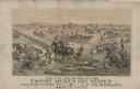
| Description: | Lithograph of the Empire Mower and Reaper; several other reaper manufacturers and models are identified in the illustration which appears above the text: “... |

| Date: | 1975 |
|---|---|
| Description: | This map provides an index of outdated quadrangle maps for the state. Communities, counties, rivers, and lakes are labeled including Lake Michigan and Lake... |
| Date: | 1850 |
|---|---|
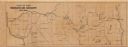
| Description: | This map shows a cross-section of southern Wisconsin, with the Milwaukee and Mississippi Railroad line running from Milwaukee to the Mississippi River near... |

| Date: | 1855 |
|---|---|
| Description: | This map shows the locations of ancient works in the state of Wisconsin. Lake Superior and Michigan are labeled. Counties, towns, and rivers are also label... |

| Date: | 1853 |
|---|---|
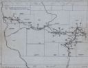
| Description: | Map of a cross-section of southern Wisconsin, highlighting the La Crosse Milwaukee Rail Road. Shows canals, railroads, plank and post roads, and township g... |

| Date: | 1947 |
|---|---|
| Description: | This map shows territorial roads laid out and opened between 1836 to 1848. Includes a scale in miles. Routes are labeled by numbers and indicated in key on... |

| Date: | 1950 |
|---|---|
| Description: | This map shows regions in Northern Illinois and Southern Wisconsin roughly bounded by Lake Winnebago, the Kankakee River, Peoria, and Prairie du Chien. The... |

| Date: | 1900 |
|---|---|
| Description: | This map shows the boundary lines between ceded and unceded land in compliance with the Treaty of Prairie du Chen of 1829. It also shows roads, rivers, por... |

| Date: | 1829 |
|---|---|
| Description: | This map shows waterways, trails, settlements, Indian villages, and boundaries. The map includes text in the lower left with excerpts from Indian land trea... |
| Date: | 1949 |
|---|---|
| Description: | This map traces the route taken Chief Black Hawk from Vernon County, Wisconsin east to Waukesha County and south to Rock County, Wisconsin in 1832. Towns, ... |

| Date: | 1856 |
|---|---|
| Description: | This map shows the railroad routes and connection of the Mineral Point Railroad. Lake Michigan is on the far right, while Lake Superior is at the top of th... |

| Date: | 1856 |
|---|---|
| Description: | This map shows the railroad routes that lead to Milwaukee. Included are portions of Minnesota, Iowa and Illinois. Lake Michigan is on the right, while Lake... |

| Date: | 1857 |
|---|---|
| Description: | This map shows the railroad routes of the Milwaukee & Horicon Railroad, common roads, counties, canals, townships, cities, county towns, villages, post off... |

| Date: | 1857 |
|---|---|
| Description: | This map shows county boundaries, larger cities, lakes, rivers, and the railroad network. The main line is in red, and the Milwaukee and Chicago Railroad i... |
| Date: | 1857 |
|---|---|
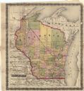
| Description: | This map shows drainage, state boundaries, county boundaries, rivers, lakes, township lines, cities, and towns. The Milwaukee & Horicon Road road is indica... |

| Date: | 1861 |
|---|---|
| Description: | This map shows railroad and other transportation routes in Wisconsin, northern Illinois, the Upper Peninsula of Michigan, portions of Iowa, Minnesota, and ... |
If you didn't find the material you searched for, our Library Reference Staff can help.
Call our reference desk at 608-264-6535 or email us at: