 Filter: Categories of Wisconsin Historical Images
Filter: FORMAT_TYPE of prints, fine-art
Filter: Subject of children and adults
Filter: Categories of Wisconsin Historical Images
Filter: FORMAT_TYPE of prints, fine-art
Filter: Subject of children and adults
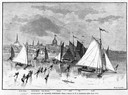
| Date: | 03 09 1878 |
|---|---|
| Description: | Illustration by N.A. Greenback of ice-skaters and iceboats featuring the new Poughkeepsie design of pivoting runners. A key at the bottom of the image iden... |

| Date: | 1860 |
|---|---|
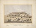
| Description: | Bird's-eye view of Janesville from the High School building. |
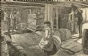
| Date: | 1879 |
|---|---|
| Description: | Drawing of a girl sitting on a barrel as a man dumps apples into a press to make cider. Two men manually operate the press at the left. |
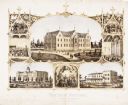
| Date: | 1867 |
|---|---|
| Description: | 1868-1875. Founded by Dr. Joseph Salzman (featured in the vignette at left, teaching). Vignette, lower left, features St. Francis Seminary, founded in 1856... |

| Date: | 08 1971 |
|---|---|
| Description: | Poster advertising for an event occurring between August 1971 and February 1972 called the "Traffic Experiment," in Madison. Features screen printed silhou... |

| Date: | 1930 |
|---|---|
| Description: | An original lithograph depicting a scene aboard a United States Lines passenger ship, featuring what appears to be the New York City skyline in the backgro... |
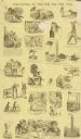
| Date: | |
|---|---|
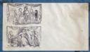
| Description: | A layout of caricatures and cartoons of a "Comicalities of the War for the Union". |
| Date: | 1869 |
|---|---|
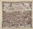
| Description: | A lithograph of the Coliseum for the Grand National Peace Jubilee in Boston, Massachusetts on June 15-19. |
| Date: | 1860 |
|---|---|
| Description: | Two images of the "family" of Virginia. Above depicts a happy, prosperous "family" at the Declaration of Independence in 1776. A banner with the stars and ... |
| Date: | 1819 |
|---|---|
| Description: | A commemorative handkerchief created by a wood engraving on white cotton fabric. The scene is the Manchester Reform Meeting, in England. A crowd of demonst... |

| Date: | |
|---|---|
| Description: | Student Nonviolence Coordinating Committee (SNCC) poster featuring an African man and child on red background. |
| Date: | 1874 |
|---|---|
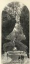
| Description: | Engraved view of Rood's Glen. A boy plays with a toy boat at bottom left while two men and a woman talk at bottom right. Two other figures can be seen in t... |
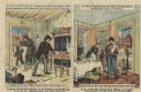
| Date: | 1884 |
|---|---|
| Description: | Political cartoon comparing the Democratic Platform with the Republican Platform. The cartoon (Democratic) on the left depicts a poor family wearing rags i... |
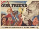
| Date: | 1944 |
|---|---|
| Description: | A poster featuring the face of President Franklin Roosevelt on the right, and several people on the left. A soldier is holding a child in his arms, and oth... |

| Date: | 1630 |
|---|---|
| Description: | One of the few maps by Dutch cartographer Willem Blaeu depicting the Americas, this map shows regions, settlements, islands, mountains, forests, rivers, an... |

| Date: | 1683 |
|---|---|
| Description: | Map of the north east coast of North America showing islands, regions, Native American land, bays, and a few European settlements. The Great Lakes appear i... |

| Date: | 1710 |
|---|---|
| Description: | Map of North America showing the European claims, Native American land and villages, rivers, lakes, cities, and notes on explorers, discoveries, and topogr... |

| Date: | 1719 |
|---|---|
| Description: | Map of North America showing land divisions between France, Spain, England, Sweden, Denmark and Holland. The map is detailed, labeling cities, forts, islan... |

| Date: | 1766 |
|---|---|
| Description: | This map of North America shows the boundaries of European claims at the end of the French and Indian war. The British colonies extend to the Mississippi. ... |

| Date: | 1733 |
|---|---|
| Description: | This map of North America shows settlements, rivers, lakes, Native American land, trade winds, and numerous topographical features such as forests and moun... |
If you didn't find the material you searched for, our Library Reference Staff can help.
Call our reference desk at 608-264-6535 or email us at: