 Filter: Categories of Wisconsin Historical Images
Filter: FORMAT_TYPE of prints, fine-art
Filter: Subject of bays
Filter: Categories of Wisconsin Historical Images
Filter: FORMAT_TYPE of prints, fine-art
Filter: Subject of bays

| Date: | 1941 |
|---|---|
| Description: | Elevated view of Sturgeon Bay in 1900. Sturgeon Bay Bridge spans the bay and several boats are on the water. A lighthouse sits on a small island in the bay... |

| Date: | 1925 |
|---|---|
| Description: | This map shows lakes, islands and bays. The Upper Peninsula of Michigan and Ontario are labeled. Three inset maps include the Upper end of St. Marys River ... |

| Date: | 1855 |
|---|---|
| Description: | This map shows current and purposed railroad routes. Lake Michigan is on the far right, with Lake Superior visible at the top of the map. Routes are marked... |

| Date: | 1831 |
|---|---|
| Description: | This map shows the land that makes up Michigan, Wisconsin, Minnesota, Indiana, and parts of Canada. The Great Lakes are displayed prominently, along with s... |
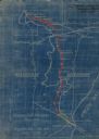
| Date: | 1923 |
|---|---|
| Description: | This blueprint map shows Wisconsin and Michigan-owned railroad and trackage rights from Iron Mountain to Menominee, Michigan, as well as other railroads. W... |
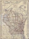
| Date: | 1933 |
|---|---|
| Description: | This map shows cities, rivers, lakes, roads, county boundaries, and destinations. Scenic and historic trails are shown in red. The map includes indexes to ... |

| Date: | 1914 |
|---|---|
| Description: | This map shows township grids, railroads, roads, and drainage. The area of the map covers northeastern Wisconsin and Menominee Indian reservation. Green Ba... |

| Date: | 1868 |
|---|---|
| Description: | This map includes a table of estimated costs "by Brev. Maj. Gen. G.K. Warren Maj. U.S.E., of improvement of Wis. River from his survey of 1867." Included a... |

| Date: | 01 01 1959 |
|---|---|
| Description: | This map shows many of the rivers, dams, bays, harbors, lakes, and canals. It includes an index of authorized federal project, both for navigation and floo... |

| Date: | 1899 |
|---|---|
| Description: | This map shows color coded and numbered regions of Indian land cessions. Lake Superior and Lake Michigan are labeled and other lakes and rivers are shown. ... |

| Date: | 1900 |
|---|---|
| Description: | This photocopy plat map of a paper city on the southeastern shore of Green Bay, probably in Brown County. The front includes a registration and the back in... |

| Date: | 1917 |
|---|---|
| Description: | This road map shows routes through the state as well as some portions of Iowa, Minnesota, and Michigan. Cities, the Mississippi River, Lake Winnebago, Gree... |

| Date: | 1927 |
|---|---|
| Description: | This map details automobile routes throughout the state as well as parts of Iowa, Minnesota, Michigan and Illinois. Cities, the Mississippi River, Lake Mic... |

| Date: | 1910 |
|---|---|
| Description: | This map shows automobile routes across the state as well as Minnesota, Iowa, Illinois, and Michigan. Cities, Lake Michigan, Lake Superior, the Mississippi... |

| Date: | 1915 |
|---|---|
| Description: | This map includes automobile routes through the state as well as routes in parts of Iowa, Michigan and Minnesota. Cities, counties, Lake Michigan, Lake Sup... |

| Date: | 1920 |
|---|---|
| Description: | This map details automobile routes spanning across Wisconsin and parts of Illinois, Michigan, Minnesota, and Iowa. Cities, counties, Lake Michigan, Lake Su... |

| Date: | 1894 |
|---|---|
| Description: | This map shows automobile routes across the state and into parts of Illinois, Michigan, Minnesota, and Iowa. Cities, counties, Lake Michigan, Lake Superior... |

| Date: | 1913 |
|---|---|
| Description: | This map details automobile routes throughout the state and parts of Illinois, Minnesota, Michigan, and Iowa. Cities, counties, Lake Michigan, Lake Superio... |

| Date: | 1924 |
|---|---|
| Description: | This map shows automobile routes across the state and into parts of Minnesota, Iowa, Illinois, and Michigan. Cities, Lake Michigan, Lake Superior, Green Ba... |

| Date: | 1919 |
|---|---|
| Description: | This map contains the automobile routes in southern Wisconsin and northern Illinois. Cities, Lake Winnebago and Green Bay are labeled. The orange print on ... |
If you didn't find the material you searched for, our Library Reference Staff can help.
Call our reference desk at 608-264-6535 or email us at: