Filter: Categories of Wisconsin Historical Images
Filter: FORMAT_TYPE of photocopy
Filter: Subject of water
Filter: Creator Name of Unknown
Filter: Categories of Wisconsin Historical Images
Filter: FORMAT_TYPE of photocopy
Filter: Subject of water
Filter: Creator Name of Unknown
| Date: | |
|---|---|
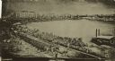
| Description: | A fleet of steamboats used by General Joseph Bailey of the Fourth Wisconsin Cavalry constructing a bridge across the Atchafalaya passage of General Banks' ... |

| Date: | |
|---|---|
| Description: | Sinking of the "Albemarle." Lieut. Cushing (?) torpedoing the ALBEMARLE. |
| Date: | 1942 |
|---|---|
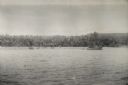
| Description: | View over water towards the New Guinea coast from a boat. A larger boat is on the right and several smaller craft in the center. A pier is on the shoreline... |

| Date: | 1925 |
|---|---|
| Description: | This map shows the public schools and their school districts. The bottom of the map reads:" Old buildings and sites in red. New buildings and sites in blac... |

| Date: | 07 2001 |
|---|---|
| Description: | David Obey poses with Park Ranger Geoffrey Smith on the left and Martin Hanson on the right. They are standing on the beach with water and land in the back... |

| Date: | 1900 |
|---|---|
| Description: | This map shows landownership circa 1848 in the old Stockbridge Indian reservation on Lake Winnebago in Calumet County. It is oriented with north to the lef... |

| Date: | 1900 |
|---|---|
| Description: | This set of photocopy bird's-eye-view maps include one view looking west from the top of Wisconsin River bluffs; and a second view looking east towards La ... |

| Date: | 1900 |
|---|---|
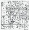
| Description: | This photocopy map shows landownership and mills in T35N, R17W as it appeared in 1885. Rice Lake, Little Balsam Lake, and Half Moon Lake are labeled. |

| Date: | 1900 |
|---|---|
| Description: | This photocopy map shows marshes, woods, buildings, and selected features including islands, mounds, old Fort Crawford, and "new site for a fort in questio... |

| Date: | 1906 |
|---|---|
| Description: | A diagram of Township No 37 Range No 8 in Sawyer County. |
| Date: | |
|---|---|
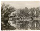
| Description: | A holiday card featuring Lake Dunmovin on the Zerk estate. The mansion is in the background on the left. On the opposite shoreline on the right is an arche... |
If you didn't find the material you searched for, our Library Reference Staff can help.
Call our reference desk at 608-264-6535 or email us at: