Filter: Categories of Wisconsin Historical Images
Filter: FORMAT_TYPE of photocopy
Filter: Subject of transportation
Filter: Year of 1900-1999
Filter: Categories of Wisconsin Historical Images
Filter: FORMAT_TYPE of photocopy
Filter: Subject of transportation
Filter: Year of 1900-1999
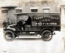
| Date: | 1920 |
|---|---|
| Description: | Driver delivering "Fresh Beef Guts and Provisions" in an International Model H 1 1/2 ton truck. The truck was owned by A. Levine. The Model H was produced ... |
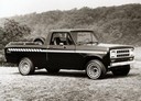
| Date: | 1980 |
|---|---|
| Description: | Advertising photograph of the International Scout Terra pickup truck. |
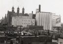
| Date: | 1940 |
|---|---|
| Description: | There is a sign painted on a building at right that reads "Schlitz". In the bottom right are railroad cars. |
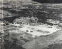
| Date: | 1955 |
|---|---|
| Description: | Aerial view of Valley Fair Mall, with a residential area beyond it on both sides of a river, all surrounded by trees and farmland. |
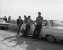
| Date: | 1961 |
|---|---|
| Description: | Four of the deputy sheriffs that were part of the growers strike-breaking techniques during the important Imperial Valley Lettuce Strike. |
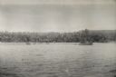
| Date: | 1942 |
|---|---|
| Description: | View over water towards the New Guinea coast from a boat. A larger boat is on the right and several smaller craft in the center. A pier is on the shoreline... |

| Date: | 06 1931 |
|---|---|
| Description: | This map is a photocopy of a map that has been hand-colored and shows streets, the Wisconsin River, Mill Pond, and points of interest that include a school... |

| Date: | 1956 |
|---|---|
| Description: | International VF-192 tandem dump truck with load of coal. Powered by V8-478 CID gas engine. Painted on the driver's side door: "Black Nugget Coal Mining Co... |

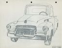
| Date: | 1936 |
|---|---|
| Description: | Clay mock-up of 1937 front end for D-30 1 1/2 ton. |
| Date: | 1900 |
|---|---|
| Description: | This map shows the blocks and streets that make up the village, and includes the Baraboo Air Line Railroad which cuts through the village at a diagonal fro... |

| Date: | 1900 |
|---|---|
| Description: | This map shows the additions made in January 1855, as well as houses, streets, Catfish Creek, and the Milwaukee and Mississippi Rail Road and Depot. It als... |

| Date: | 1900 |
|---|---|
| Description: | This map shows AS&IR Railroad between Siskiwit and Nash (with dock), a proposed extension of AS&IR Railroad "now under construction" between Superior and N... |
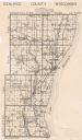
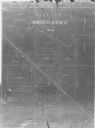
| Date: | 1913 |
|---|---|
| Description: | This map shows landownership, rural mail routes, rural buildings, railroads, U.S. national highways, state trunk highways, county trunk highways, township... |
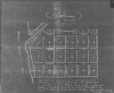
| Date: | 1900 |
|---|---|
| Description: | Plat map showing a paper city located on the Wisconsin River. The map includes a public square, street names, and a note written by Francis Headman. |

| Date: | 1904 |
|---|---|
| Description: | Map showing lots, additions, and wards within the city limits, as well as some landownership. The streets are labeled, as is Lake Winnebago, rivers, railro... |

| Date: | 01 17 1939 |
|---|---|
| Description: | Three-quarter view from front right of D-Line truck parked in the snow outdoors. A spare tire is mounted on the outside of the open bed just behind the pas... |

| Date: | 1900 |
|---|---|
| Description: | Map showing a paper city on the shore of Lake Apuckwa (Lake Puckaway) in Marquette or Green Lake County. The map includes certifications signed by John V. ... |

| Date: | 1900 |
|---|---|
| Description: | Map showing a paper city located on the shore of Green Bay and south shore of the Fox River. The site is now part of Oshkosh. |

| Date: | 1900 |
|---|---|
| Description: | Map showing city wards, streets, block and lot numbers, additions, selected buildings, Lake Winnebago, the Fox River, and railroads as of 1895. The lower m... |
If you didn't find the material you searched for, our Library Reference Staff can help.
Call our reference desk at 608-264-6535 or email us at: