 Filter: Categories of Wisconsin Historical Images
Filter: FORMAT_TYPE of photocopy
Filter: Subject of streets
Filter: Categories of Wisconsin Historical Images
Filter: FORMAT_TYPE of photocopy
Filter: Subject of streets
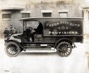
| Date: | 1920 |
|---|---|
| Description: | Driver delivering "Fresh Beef Guts and Provisions" in an International Model H 1 1/2 ton truck. The truck was owned by A. Levine. The Model H was produced ... |

| Date: | 06 1931 |
|---|---|
| Description: | This map is a photocopy of a map that has been hand-colored and shows streets, the Wisconsin River, Mill Pond, and points of interest that include a school... |
| Date: | 1900 |
|---|---|
| Description: | This map shows the blocks and streets that make up the village, and includes the Baraboo Air Line Railroad which cuts through the village at a diagonal fro... |

| Date: | 1900 |
|---|---|
| Description: | This map shows the additions made in January 1855, as well as houses, streets, Catfish Creek, and the Milwaukee and Mississippi Rail Road and Depot. It als... |

| Date: | 1835 |
|---|---|
| Description: | Map shows the Fox River, lot and block numbers, private claims, streets, a public squares, a manual labour school, and Fort Howard. An inset map shows a pl... |
| Date: | 1900 |
|---|---|
| Description: | Plat map showing a paper city located on the Wisconsin River. The map includes a public square, street names, and a note written by Francis Headman. |

| Date: | 1904 |
|---|---|
| Description: | Map showing lots, additions, and wards within the city limits, as well as some landownership. The streets are labeled, as is Lake Winnebago, rivers, railro... |

| Date: | 1900 |
|---|---|
| Description: | Map showing a paper city on the shore of Lake Apuckwa (Lake Puckaway) in Marquette or Green Lake County. The map includes certifications signed by John V. ... |

| Date: | 1900 |
|---|---|
| Description: | Map showing a paper city located on the shore of Green Bay and south shore of the Fox River. The site is now part of Oshkosh. |

| Date: | 1900 |
|---|---|
| Description: | Map showing city wards, streets, block and lot numbers, additions, selected buildings, Lake Winnebago, the Fox River, and railroads as of 1895. The lower m... |

| Date: | 1947 |
|---|---|
| Description: | Map showing plats, streets, and the public square. The bottom margin of the map includes registration and certifications. |

| Date: | 1947 |
|---|---|
| Description: | This photocopy of a hand-drawn map shows streets, a public square, lots, and extensive registrations and certifications. |

| Date: | 1900 |
|---|---|
| Description: | This photocopy map shows blocks, lots, subdivisions, city wards, buildings, some landownership, and the Mississippi River. The map margins include business... |

| Date: | 1900 |
|---|---|
| Description: | This photocopy plat map of Pauquette, now Poynette, shows streets and lot numbers. |

| Date: | 1921 |
|---|---|
| Description: | This map shows selected streets, public buildings, churches, schools, businesses, warehouses, the harbor, the Root River, and Lake Michigan. The map includ... |

| Date: | |
|---|---|
| Description: | Entrance into Berlin of the first battle trophies on Sedantage (anniversary of the Battle of Sedan). The column is being led by Colonel Jakobi. |
If you didn't find the material you searched for, our Library Reference Staff can help.
Call our reference desk at 608-264-6535 or email us at: