 Filter: Categories of Wisconsin Historical Images
Filter: FORMAT_TYPE of photocopy
Filter: Subject of human settlements
Filter: Categories of Wisconsin Historical Images
Filter: FORMAT_TYPE of photocopy
Filter: Subject of human settlements
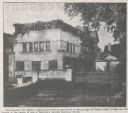
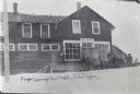
| Date: | 04 30 1913 |
|---|---|
| Description: | Newspaper photograph of the Robert Lamp home, 22 North Butler Street, built by Frank Lloyd Wright in 1903, and hidden in the center of one of Madison's upt... |
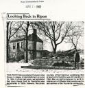
| Date: | 03 24 1983 |
|---|---|
| Description: | Newspaper clipping showing the demolishing of the Long House. The man on the right is believed to be M.V. Adkins, son of Chester Adkins, the last survivor ... |

| Date: | 1886 |
|---|---|
| Description: | Detail of map including plans of the National Soldiers' home. |
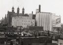
| Date: | 1940 |
|---|---|
| Description: | There is a sign painted on a building at right that reads "Schlitz". In the bottom right are railroad cars. |
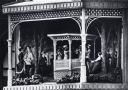
| Date: | 1970 |
|---|---|
| Description: | Close-up detail of scene of historic Wisconsin in a hexagonal structure on a pedestal beneath the clock. The scene depicts an outdoor band concert in Milwa... |
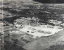
| Date: | 1955 |
|---|---|
| Description: | Aerial view of Valley Fair Mall, with a residential area beyond it on both sides of a river, all surrounded by trees and farmland. |
| Date: | |
|---|---|
| Description: | A stagecoach full of people is outside the post office on snow-covered ground, waiting to leave town. Text on image reads: "Stage, Leaving Arbor Vitae, Wis... |
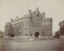
| Date: | |
|---|---|
| Description: | Exterior view from across Langdon Street of the Red Gym (Armory or Old Red) on the University of Wisconsin-Madison campus. |
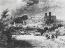
| Date: | 1810 |
|---|---|
| Description: | View of the city of Lincoln, England. Photocopy after an engraving by B.G. Topham. |

| Date: | 1925 |
|---|---|
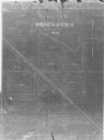
| Description: | This map shows the public schools and their school districts. The bottom of the map reads:" Old buildings and sites in red. New buildings and sites in blac... |

| Date: | 06 1931 |
|---|---|
| Description: | This map is a photocopy of a map that has been hand-colored and shows streets, the Wisconsin River, Mill Pond, and points of interest that include a school... |
| Date: | 1900 |
|---|---|
| Description: | This map shows the blocks and streets that make up the village, and includes the Baraboo Air Line Railroad which cuts through the village at a diagonal fro... |

| Date: | 1900 |
|---|---|
| Description: | This map shows the additions made in January 1855, as well as houses, streets, Catfish Creek, and the Milwaukee and Mississippi Rail Road and Depot. It als... |
| Date: | 1911 |
|---|---|
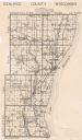
| Description: | This map includes references to reservoirs, industrial sites, and drainage basins. |

| Date: | 1900 |
|---|---|
| Description: | This map shows AS&IR Railroad between Siskiwit and Nash (with dock), a proposed extension of AS&IR Railroad "now under construction" between Superior and N... |
| Date: | 1878 |
|---|---|
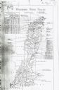
| Description: | This map includes business directories, statistical table, distance table, list of county officers, and illustrated views of residential and commercial pro... |

| Date: | 1836 |
|---|---|
| Description: | This map shows land parcels, streets, the Fond du Lac River, Lake Winnebaygo (Winnebago), and blocks. Certification is on the left hand corner. The back of... |
| Date: | 1913 |
|---|---|
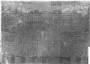
| Description: | This map shows landownership, rural mail routes, rural buildings, railroads, U.S. national highways, state trunk highways, county trunk highways, township... |

| Date: | 1835 |
|---|---|
| Description: | Map shows the Fox River, lot and block numbers, private claims, streets, a public squares, a manual labour school, and Fort Howard. An inset map shows a pl... |

| Date: | 1900 |
|---|---|
| Description: | This set of photocopy bird's-eye-view maps include one view looking west from the top of Wisconsin River bluffs; and a second view looking east towards La ... |
If you didn't find the material you searched for, our Library Reference Staff can help.
Call our reference desk at 608-264-6535 or email us at: