 Filter: Categories of Wisconsin Historical Images
Filter: FORMAT_TYPE of photocopy
Filter: Creator Name of Unknown
Filter: Year of 1900-1999
Filter: Categories of Wisconsin Historical Images
Filter: FORMAT_TYPE of photocopy
Filter: Creator Name of Unknown
Filter: Year of 1900-1999
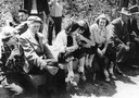
| Date: | 1949 |
|---|---|
| Description: | Landscape architect Jens Jensen and youth from the Madison Youth Council at Glenwood Children's park on their clean-up work day. The park was planned and d... |
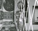
| Date: | 07 27 1953 |
|---|---|
| Description: | A visitor to the Wisconsin State Fair is so curious about one entry in a display of rugs and textiles that she reaches through a protective barrier in orde... |
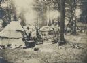
| Date: | 1906 |
|---|---|
| Description: | The Lac Courte Oreilles village sponsored by the Wisconsin Archaeological Society at the 1906 Wisconsin State Fair. Several members of the society are incl... |
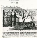
| Date: | 03 24 1983 |
|---|---|
| Description: | Newspaper clipping showing the demolishing of the Long House. The man on the right is believed to be M.V. Adkins, son of Chester Adkins, the last survivor ... |
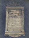
| Date: | 1900 |
|---|---|
| Description: | Plaque marking the site of the first Court House, first and second jails, and the first County Offices. Erected by Milwaukee County, the plaque has classi... |
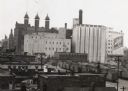
| Date: | 1940 |
|---|---|
| Description: | There is a sign painted on a building at right that reads "Schlitz". In the bottom right are railroad cars. |
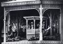
| Date: | 1970 |
|---|---|
| Description: | Close-up detail of scene of historic Wisconsin in a hexagonal structure on a pedestal beneath the clock. The scene depicts an outdoor band concert in Milwa... |

| Date: | 1961 |
|---|---|
| Description: | Four of the deputy sheriffs that were part of the growers strike-breaking techniques during the important Imperial Valley Lettuce Strike. |
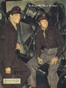
| Date: | 1943 |
|---|---|
| Description: | Lt. Ronald Reagan and Corp. Craig Stevens on the set of the Warner Brothers' film "This is the Army." |

| Date: | 1964 |
|---|---|
| Description: | Official portrait of David R. Obey from the 1964 Wisconsin Blue Book. |
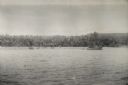
| Date: | 1942 |
|---|---|
| Description: | View over water towards the New Guinea coast from a boat. A larger boat is on the right and several smaller craft in the center. A pier is on the shoreline... |

| Date: | 1925 |
|---|---|
| Description: | This map shows the public schools and their school districts. The bottom of the map reads:" Old buildings and sites in red. New buildings and sites in blac... |
| Date: | 1972 |
|---|---|
| Description: | Letterhead for the Commandos Project I organization. |

| Date: | 1900 |
|---|---|
| Description: | This map shows landownership circa 1848 in the old Stockbridge Indian reservation on Lake Winnebago in Calumet County. It is oriented with north to the lef... |

| Date: | 1900 |
|---|---|
| Description: | This set of photocopy bird's-eye-view maps include one view looking west from the top of Wisconsin River bluffs; and a second view looking east towards La ... |

| Date: | 1900 |
|---|---|
| Description: | This photocopy map shows landownership and mills in T35N, R17W as it appeared in 1885. Rice Lake, Little Balsam Lake, and Half Moon Lake are labeled. |

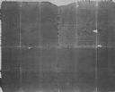
| Date: | 1900 |
|---|---|
| Description: | This photocopy map shows marshes, woods, buildings, and selected features including islands, mounds, old Fort Crawford, and "new site for a fort in questio... |
| Date: | 1930 |
|---|---|
| Description: | This photocopy map includes cross section of buildings. |

| Date: | 1900 |
|---|---|
| Description: | This photocopy plat map of Pauquette, now Poynette, shows streets and lot numbers. |
If you didn't find the material you searched for, our Library Reference Staff can help.
Call our reference desk at 608-264-6535 or email us at:
