Filter: Categories of Wisconsin Historical Images
Filter: FORMAT_TYPE of negative, b/w copy
Filter: Subject of intellectual life
Filter: Categories of Wisconsin Historical Images
Filter: FORMAT_TYPE of negative, b/w copy
Filter: Subject of intellectual life
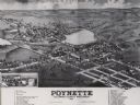
| Date: | 1882 |
|---|---|
| Description: | Bird's-eye map of Poynette, with one vignette. |
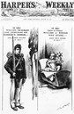
| Date: | 08 29 1896 |
|---|---|
| Description: | Cover of Harper's Weekly, with a pro-William McKinley Presidential cartoon depicting McKinley as a soldier in 1861 and William Jennings Bryan as an ... |

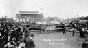
| Date: | 09 11 1955 |
|---|---|
| Description: | The crowd at "Air Progress Day," an air show sponsored by the Waukesha Aviation Club. |
| Date: | 1911 |
|---|---|
| Description: | John Schwister and his home-built airplane, "the Minnesota Badger," at the Langlade County Fairgrounds. |
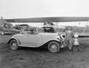
| Date: | 08 1928 |
|---|---|
| Description: | John P. Wood of Wausau, winner of the 1928 National Air Reliability Tour, with his "Waco from Wausau." Also in the photograph are Wood's prizes: the Edsel ... |

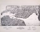
| Date: | 1874 |
|---|---|
| Description: | Bird's-eye map of Chippewa Falls. |

| Date: | 12 21 1882 |
|---|---|
| Description: | Bird's-eye map of Kaukauna, from the Appleton Post Annual Review. |

| Date: | 1892 |
|---|---|
| Description: | Bird's-eye map of Princeton, with an inset of the Residence of F.T. Yahr. Fox River loops to left of center, with one bridge; thirty-six businesses, reside... |

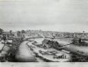
| Date: | 1875 |
|---|---|
| Description: | Bird's-eye map after a fire destroyed a large area of the town. In memory of the Great Conflagration on April 28th, 1875. Taken from the North-Side. |

| Date: | 1893 |
|---|---|
| Description: | Bird's-eye map of Sturgeon Bay, looking Northeast. Area bordered by Church Street in top left corner, leather & Smith Bridge in bottom left corner, Lawrenc... |

| Date: | 1880 |
|---|---|
| Description: | Bird's-eye map of Sturgeon Bay. County Seat of Door County. |

| Date: | 1881 |
|---|---|
| Description: | Bird's-eye view of Appleton. |

| Date: | 02 26 1887 |
|---|---|
| Description: | Bird's-eye map of Ashland, and the Apostle Islands in Lake Superior. Caption reads: "Ashland and the Apostle Islands." |
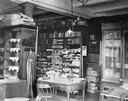
| Date: | 1898 |
|---|---|
| Description: | Cluttered work space of the librarian responsible for the Historical Society's newspaper collection during the period when the Society occupied rooms in th... |
If you didn't find the material you searched for, our Library Reference Staff can help.
Call our reference desk at 608-264-6535 or email us at: