 Filter: Categories of Wisconsin Historical Images
Filter: FORMAT_TYPE of manuscript
Filter: Subject of maps
Filter: Categories of Wisconsin Historical Images
Filter: FORMAT_TYPE of manuscript
Filter: Subject of maps
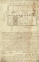
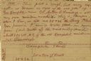
| Date: | 01 12 1844 |
|---|---|
| Description: | Letter from Thomas Steel, Waukesha County physician and farmer, to his father, James Steel, in London, England. It includes a hand-drawn map of Milwaukee C... |
| Date: | |
|---|---|
| Description: | Plat map of Mammoth Cave. A note on the map reads: "Mrs. Campbell conjectures that this is a saltpeter cave in Green River, Kentucky. The mummy found in it... |
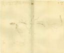
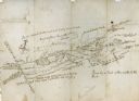
| Date: | 11 26 1846 |
|---|---|
| Description: | A drawing by Thomas Steel of his farm property contained in a letter Steel wrote to his father James Steel. |
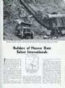
| Date: | 03 1932 |
|---|---|
| Description: | Page from International Trail magazine featuring an article about the use of International trucks for the construction of the Hoover Dam. The title ... |
| Date: | 07 04 1776 |
|---|---|
| Description: | Notes written in red ink on the back of the map of the Battle of Black's Fort. |
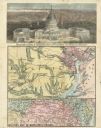
| Date: | 08 1861 |
|---|---|
| Description: | Large-format, illustrated stationery purchased by Rudolph Fine, a member of the 6th Wisconsin Infantry in August, 1861, showing the Capitol (in actuality, ... |
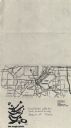
| Date: | 1979 |
|---|---|
| Description: | Map for location of the Magic Picnic, a celebration of the lesbian and gay community, which took place in Brittingham Park. |
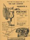
| Date: | 1979 |
|---|---|
| Description: | Poster for picnic presented by the Gay Center at Vilas Park. Includes an image of a fox and telephone. |
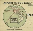
| Date: | 1890 |
|---|---|
| Description: | Letterhead for Moulton, Moran & Co. The logo shows North America and depicts Superior as the center of a hub with spokes going to Russia, to China and Japa... |
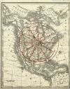
| Date: | 1890 |
|---|---|
| Description: | Rand, McNally map of North America enhanced to show Superior as the center of a wheel. The image was used on the back of stationery from City Improvement C... |
| Date: | |
|---|---|
| Description: | Hand-drawn map including the Clinch River and Clinch mountain range. The Clinch River rises in Southwest Virginia near Tazewell, VA and flows southwest thr... |

| Date: | |
|---|---|
| Description: | Back, front, and inside front cover of the menu from The Restaurant at Baron's department store, with "A Historical Map of Madison" focusing on the isthmus... |

| Date: | |
|---|---|
| Description: | Map and advertisement for the Casa del Norte Tea Rooms, with a grid of several blocks in downtown Duluth highlighting the tea rooms as well as other notabl... |
| Date: | 03 26 1944 |
|---|---|
| Description: | Front cover and menu listing from the Villa Ferrovieri in Italy with the Chicago Milwaukee St. Paul & Pacific (CMSP&P) logo printed in red ink on the cover... |
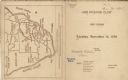
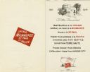
| Date: | 11 14 1899 |
|---|---|
| Description: | Front and back covers of the first dinner of the Six O'Clock Club held at the Park Hotel, with a map on the back cover of the southern tip of Africa, with ... |
| Date: | 1952 |
|---|---|
| Description: | Front cover and menu page for a banquet given by the Instituto Mexicano del Seguro Social to the senior delegates to the fourth reunion of the Inter-Americ... |

| Date: | |
|---|---|
| Description: | Front and back covers of the Mortons Surf Club menu, with a black on blue grid of Chicago streets from Lake Michigan to Vincennes Avenue, and E. 45th to E.... |

| Date: | 1953 |
|---|---|
| Description: | Front and back of one-page menu from the Scandia Restaurant, with a whimsical cartoon map rendering by Hakon Mielche of the Scandinavian countries and the ... |

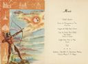
| Date: | 07 21 1951 |
|---|---|
| Description: | Luncheon menu for the S.S. Argentina, with a map of Argentina with spot illustrations for the provinces and featured products or symbols, the coat o... |
If you didn't find the material you searched for, our Library Reference Staff can help.
Call our reference desk at 608-264-6535 or email us at:
