 Filter: Categories of Wisconsin Historical Images
Filter: FORMAT_TYPE of manuscript
Filter: Type of Map or Atlas
Filter: Categories of Wisconsin Historical Images
Filter: FORMAT_TYPE of manuscript
Filter: Type of Map or Atlas

| Date: | 1908 |
|---|---|
| Description: | Five volumes of the Crown Collection of American Maps, plus an index, showing the spines of these books. |

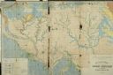
| Date: | 1848 |
|---|---|
| Description: | In 1849, northern Wisconsin was composed of huge sectional regions such as Chippewa, Portage, Brown and Crawford, whereas southern Wisconsin was constitute... |

| Date: | 1923 |
|---|---|
| Description: | Map of Oneida County-Rhinelander Airport which was laid out at the county fairgrounds. The map appears on the reverse side of a letter Roy Larson received ... |

| Date: | 1804 |
|---|---|
| Description: | A map of Lewis and Clark's Track across the western portion of North America from the Mississippi River to the Pacific Ocean by order of the Executive of t... |
| Date: | |
|---|---|
| Description: | Geological Map of the lead regions in Wisconsin, Illinois and Iowa. |
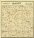
| Date: | 1873 |
|---|---|
| Description: | Columbia County Atlas Arlington Township 10 North Range 9 East. |

| Date: | 1909 |
|---|---|
| Description: | Map of Sawyer County with an advertisement for land sales through Fuley & Quail of Hayward, Wisconsin. There is a small inset map of railroads accessible i... |
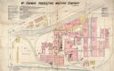
| Date: | 12 1898 |
|---|---|
| Description: | Fire insurance map showing the grounds and buildings of the McCormick Reaper Works, a factory operated by the McCormick Harvesting Machine Company. |

| Date: | 1885 |
|---|---|
| Description: | Fire insurance map of the McCormick Reaper Works, a factory of the McCormick Harvesting Machine Company. |
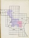
| Date: | 1935 |
|---|---|
| Description: | Map of a portion of Central Wisconsin with areas zoned for reforestation. The area is divided into two sites which are shaded in purple and red. |

| Date: | 1935 |
|---|---|
| Description: | Map of Juneau County showing area zoned for reforestation shaded in red. |

| Date: | |
|---|---|
| Description: | Map and advertisement for the Casa del Norte Tea Rooms, with a grid of several blocks in downtown Duluth highlighting the tea rooms as well as other notabl... |

| Date: | 1893 |
|---|---|
| Description: | Map of Wisconsin showing Michigan's upper peninsula, the northern portion of Illinois and part of eastern Minnesota. There is an inset map of Isle Royale i... |
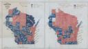
| Date: | 1900 |
|---|---|
| Description: | Hand-drawn and colored maps of Wisconsin showing how each county voted in the gubernatorial race of 1865, and on a referendum regarding suffrage for Africa... |
If you didn't find the material you searched for, our Library Reference Staff can help.
Call our reference desk at 608-264-6535 or email us at:


