 Filter: Categories of Wisconsin Historical Images
Filter: FORMAT_TYPE of drawings
Filter: Subject of writing
Filter: Categories of Wisconsin Historical Images
Filter: FORMAT_TYPE of drawings
Filter: Subject of writing

| Date: | 1876 |
|---|---|
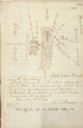
| Description: | A sketch map of the procession of Indian mounds on the two ridged field sites in Grant County. |
| Date: | |
|---|---|
| Description: | Drawn map of Landsford, South Carolina, from Thomas Sumter Papers. |
| Date: | 08 18 1881 |
|---|---|
| Description: | Sketchbook page with inscription across top in brown ink: "To Mr. Stager from his section in remembrance of the pleasant hours spent together. Aug. 18th 1... |
| Date: | 10 19 1847 |
|---|---|
| Description: | Sketch of the Camden Depot in a letter from John McRae to James Gadsdeg. |
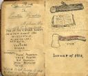
| Date: | 1903 |
|---|---|
| Description: | First interior pages of a log book kept by Preston Reynolds on his trip down the Wisconsin and Mississippi Rivers in 1903. The page lists the names of the ... |
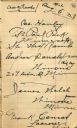
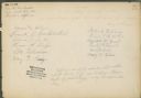
| Date: | 08 05 1903 |
|---|---|
| Description: | Signatures of the crew of the steamer Rambo. |
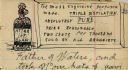
| Date: | 1903 |
|---|---|
| Description: | Drawing of a perfume bottle labeled "Attar of Clam" with a sign reading: "The most exquisite perfume made. TRIPLE DISTILLATION. Absolutely PURE |

| Date: | 1863 |
|---|---|
| Description: | This map is a hand-colored, pen and ink, drawing by Ole R. Dahl of Co. B, 15 Wisconsin Infantry shows the battlefield at Stones River, depicting roads, str... |
| Date: | 1880 |
|---|---|
| Description: | This plat of Vanceburg Cemetery, Town of Sheridan, Dunn County, Wisconsin, likely dates from the 1880s and "is intended for the correction of names of peop... |

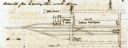
| Date: | 08 17 1874 |
|---|---|
| Description: | This manuscript drawing provides a side elevation, plan, and perspective view for a proposed lock on the Fox River. |

| Date: | 06 1837 |
|---|---|
| Description: | Pen-and-ink on paper. Shows riverside property west of the Milwaukee River. Inscribed by several early Milwaukee settlers, including Henry W. Cleveland, Cy... |

| Date: | 1855 |
|---|---|
| Description: | Pen-and-ink on paper. Includes certifications signed by surveyor and by "John T. Perkins, by his attorney I.A. Lapham." Inscribed and signed certification ... |

| Date: | 1848 |
|---|---|
| Description: | Pen-and-ink on paper. Includes certifications signed by "Geo R. Bluntz, District Survey of Grant Co. W.T." and Ben C. Eastman. |
| Date: | 08 1851 |
|---|---|
| Description: | Ink on paper. Includes explanation and a certification signed by Jacob Marty, Electa Marty, and a justice of the peace. Original map is very light and in f... |

| Date: | 1856 |
|---|---|
| Description: | This map of Woodman's Addition in Mineral Point is pen-and-ink on paper. The map includes certifications signed by John B. Whitelaw (surveyor), Cyrus Woodm... |

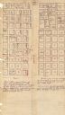
| Date: | 1856 |
|---|---|
| Description: | This map is ink and pencil on paper and shows plat of the town, local streets, and blocks and lots by number. The map includes explanatory text. |

| Date: | 1948 |
|---|---|
| Description: | This map is ink on tracing paper and shows acreages, wards, streets, rivers, and Lake Michigan. Also included are editorial notes in pencil. |
| Date: | 1909 |
|---|---|
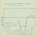
| Description: | A hand-drawn cyanotype chart tracking Piffy's (Charles Isley's) morale. |
| Date: | 1910 |
|---|---|
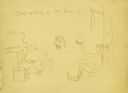
| Description: | Carl's cartoon drawing of himself and Howard ("dad") Greene. Dad is relaxing by a tree smoking a tobacco pipe while Carl is busily writing. |
| Date: | 1906 |
|---|---|
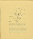
| Description: | A drawing of The Gang's camp on a hill next to Eagle River. The drawing includes the river, a road, and a bridge. Arrows drawn on the river show the direct... |
If you didn't find the material you searched for, our Library Reference Staff can help.
Call our reference desk at 608-264-6535 or email us at: