 Filter: Categories of Wisconsin Historical Images
Filter: FORMAT_TYPE of drawings
Filter: Subject of wisconsin
Filter: Categories of Wisconsin Historical Images
Filter: FORMAT_TYPE of drawings
Filter: Subject of wisconsin

| Date: | |
|---|---|
| Description: | A Menominee Indian Village on Wolf River. There are dwellings on the shore and many people in canoes are on the river. |

| Date: | 04 12 1912 |
|---|---|
| Description: | Diagram of a bird effigy mound found in Frost's Woods, Blooming Grove Township. |

| Date: | 1800 |
|---|---|
| Description: | This map is pencil on tracing paper and shows marshes, the Wisconsin River, Indian trails, and Indian boundary line. The upper left corner reads: "Let sect... |

| Date: | 1941 |
|---|---|
| Description: | This map is ink and watercolor on cardboard and shows Native American legends and villages pictorially. Trails are also shown. |
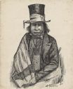
| Date: | 1850 |
|---|---|
| Description: | Waist-up pen and ink drawing of Chief Oshkosh. He is wearing a top hat wrapped with a ribbon. He wears a suitcoat, bowtie, beaded neckpouch and a blanket w... |

| Date: | |
|---|---|
| Description: | This map is pen-and-ink on tracing paper with a mounted legend and shows the Kickapoo River, Indian mounds, the 1st Fort Crawford, an Indian Agency, the si... |
If you didn't find the material you searched for, our Library Reference Staff can help.
Call our reference desk at 608-264-6535 or email us at:
