 Filter: Categories of Wisconsin Historical Images
Filter: FORMAT_TYPE of drawings
Filter: Subject of water
Filter: Community of Milwaukee
Filter: Categories of Wisconsin Historical Images
Filter: FORMAT_TYPE of drawings
Filter: Subject of water
Filter: Community of Milwaukee
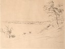
| Date: | 08 1852 |
|---|---|
| Description: | Pencil drawing of a lake shoreline. A few trees frame the arc of the shore and steamboats are visible along the distant shore. |

| Date: | 08 1852 |
|---|---|
| Description: | Pencil drawing of Milwaukee Harbor with large sailboats on the water. In the minimalist depiction the sandy shoreline with short plant growth sweeps aroun... |
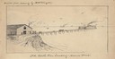
| Date: | 1850 |
|---|---|
| Description: | An illustration of the Old North Pier landing on Huron Street, drawn from memory. |

| Date: | 1833 |
|---|---|
| Description: | Published in James Smith Buck's, "Pioneer History of Milwaukee". Lake Michigan is on the right, with three rivers that combine at different points and reac... |

| Date: | 1833 |
|---|---|
| Description: | Drawing on a faint grid with Lake Michigan on the right, and the rivers on the left. Labeled is an Indian Village, J. Veiu, S. Juneau, and P. Juneau. Alo... |
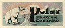
| Date: | 07 02 1935 |
|---|---|
| Description: | Label submitted to the State of Wisconsin for trademark registration. Features a polar bear licking a large ice cream cone. There are floating blocks of ic... |

| Date: | 1830 |
|---|---|
| Description: | An ink on paper, hand-drawn map of the town of Milwaukee, showing the divisions and landownership within the town by private individuals as well as those l... |

| Date: | 1835 |
|---|---|
| Description: | This map is pen-and-ink on paper. The map shows landowners in "Milwalky" or present day Milwaukee. Includes "list of property offered to Mr. Walker". The m... |

| Date: | 1835 |
|---|---|
| Description: | Plat map of Milwaukee. Pen-and-ink and watercolor on paper. Certifications on back side signed by several early settlers, as well as a justice of the peace... |

| Date: | 1836 |
|---|---|
| Description: | Pencil on tracing paper. Rough sketch of Milwaukee. Left top corner reads: "From Map of northern part of Illinois and the surveyed part of Wisconsin Territ... |

| Date: | 06 1837 |
|---|---|
| Description: | Pen-and-ink on paper. Shows riverside property west of the Milwaukee River. Inscribed by several early Milwaukee settlers, including Henry W. Cleveland, Cy... |

| Date: | 1840 |
|---|---|
| Description: | Pen-and-ink on paper. Map shows 1840’s homes with owner names, a Native American cemetery, and other points of interest. Relief shown by hachures. Oriented... |

| Date: | 1910 |
|---|---|
| Description: | This ink on paper blue line print base map consists of eight separate pieces and shows city limits, The Milwaukee Electric Railroad & Light Company lines, ... |

| Date: | 1948 |
|---|---|
| Description: | This map is ink on tracing paper and shows acreages, wards, streets, rivers, and Lake Michigan. Also included are editorial notes in pencil. |
If you didn't find the material you searched for, our Library Reference Staff can help.
Call our reference desk at 608-264-6535 or email us at: