 Filter: Categories of Wisconsin Historical Images
Filter: FORMAT_TYPE of drawings
Filter: Subject of transportation
Filter: Categories of Wisconsin Historical Images
Filter: FORMAT_TYPE of drawings
Filter: Subject of transportation

| Date: | 1850 |
|---|---|
| Description: | Map is pen and pencil on paper. The map shows roads, creeks, and the Chequamegon Bay. The map is undated and prepared sometime between the establishment of... |
| Date: | 03 03 1937 |
|---|---|
| Description: | A pencil drawing of a proposed area of the planned community of Greendale, Wisconsin. The community was established as an objective of the Department of Ag... |

| Date: | 1900 |
|---|---|
| Description: | This map of Bangor is ink and pencil on cloth. The map shows roads, railroads, residences, mills, the original plat of Bangor, and the Wisconsin and Wheldo... |
| Date: | 1938 |
|---|---|
| Description: | Architectural drawing of the Sunset Village neighborhood on the West side of the city of Madison. The poster description reads: A proposed master plan for ... |
| Date: | 1863 |
|---|---|
| Description: | This plat map of Brillion is ink and pencil on paper. The front of the map shows a plat of the town, roads, and Spring Creek, and includes a significant ha... |

| Date: | 1856 |
|---|---|
| Description: | This map of Woodman's Addition in Mineral Point is pen-and-ink on paper. The map includes certifications signed by John B. Whitelaw (surveyor), Cyrus Woodm... |

| Date: | 1829 |
|---|---|
| Description: | This map of Munnomonee is ink and pencil on tracing cloth. The map shows a plat of the town, local streets, highways, land donations for public use, and pa... |

| Date: | 1856 |
|---|---|
| Description: | This map of the City of La Crosse is a plat of Pike & Co's Addition. The map shows street names, block and lot numbers, the South La Crosse River, and the ... |
| Date: | 1840 |
|---|---|
| Description: | This map of La Crosse is ink and pencil on paper and shows lot and block numbers, as well as buildings. An inscription on the bottom of the map reads: "Tim... |

| Date: | 1880 |
|---|---|
| Description: | This map of the southern part of La Crosse is pen on cloth and shows proposed streets crossing the lands of Jane Usher and the Green Bay, Winona and St. Pa... |

| Date: | 1800 |
|---|---|
| Description: | This map of North La Crosse is ink and pencil on paper and shows lot ownership and buildings. |

| Date: | 1800 |
|---|---|
| Description: | This map of the Little Kaukalin Region is ink on paper and shows Little Kaukalin Rapids, Black Bird Island, buildings, trails, meadows and woods, and a sug... |

| Date: | |
|---|---|
| Description: | A hand-drawn map of Camp Curtis which was prepared for Colonel R. McMurphy. |

| Date: | 1872 |
|---|---|
| Description: | This map is pencil, ink, and watercolor on paper. Shown on the map is the elevation and profile of La Crescent Bottoms, Mt. Vernon Street line, 13th Street... |

| Date: | 1900 |
|---|---|
| Description: | The map is watercolor, pencil, and ink on tracing cloth and shows plats of both cities, local streets, railroads, mills, township divisions, bridges, and p... |

| Date: | 1900 |
|---|---|
| Description: | This map is pencil on tracing paper and shows profiles of local streets. Sheet 6 is hand-colored and some sheets are missing. |

| Date: | 1856 |
|---|---|
| Description: | This map is ink and pencil on paper and shows plat of the town, local streets, and blocks and lots by number. The map includes explanatory text. |
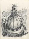
| Date: | |
|---|---|
| Description: | Drawing of the Wisconsin State Capitol building. Features the dome with the "Wisconsin" statue replaced by a seated beekeeper wearing protective clothing, ... |
| Date: | 1930 |
|---|---|
| Description: | This map is pen and pencil on paper and shows local streets, lots by number, and section divisions. |
| Date: | 1967 |
|---|---|
| Description: | This map is pen and pencil on paper and shows land ownership by name, blocks, lots, local streets, and railroads. To the right of the title the map reads: ... |
If you didn't find the material you searched for, our Library Reference Staff can help.
Call our reference desk at 608-264-6535 or email us at: