 Filter: Categories of Wisconsin Historical Images
Filter: FORMAT_TYPE of drawings
Filter: Subject of transportation
Filter: Categories of Wisconsin Historical Images
Filter: FORMAT_TYPE of drawings
Filter: Subject of transportation
| Date: | 06 09 1986 |
|---|---|
| Description: | A blueprint prepared for Emile de Antonio by the de Pavloff Company in San Francisco. The blueprint is a rendering of "Rainbow Warrior II," a proposed nava... |

| Date: | 1930 |
|---|---|
| Description: | This manuscript map, likely drawn in the 1930s, shows Fox Lake, in Dodge County, Wisconsin, and the roads and resorts in the vicinity. |

| Date: | 08 17 1874 |
|---|---|
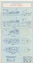
| Description: | This manuscript drawing provides a side elevation, plan, and perspective view for a proposed lock on the Fox River. |

| Date: | 1800 |
|---|---|
| Description: | This pen and ink drawing with watercolor shows the course of the Black River from Rock Creek, near Greenwood in Clark County, Wisconsin, to its confluence ... |

| Date: | 1881 |
|---|---|
| Description: | Ink, watercolor, and pencil on paper. Top of the map reads: "NORTHERN OUTLET MENASHA MEANDER LINES Scale 132ft 1 INCH Var S.E. Survey Completed Spet. 23 18... |
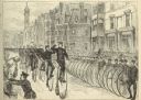
| Date: | 05 30 1881 |
|---|---|
| Description: | Engraving of a sketch by Joseph Pennell showing a parade of League of American Wheelmen bicyclists along Commonwealth Avenue between Dartmouth Street and W... |
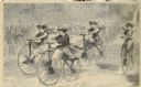
| Date: | 12 1868 |
|---|---|
| Description: | Engraved view of four women racing on bicycles. Spectators in the background are behind a fence. |

| Date: | 1855 |
|---|---|
| Description: | Pen-and-ink on paper. Includes certifications signed by surveyor and by "John T. Perkins, by his attorney I.A. Lapham." Inscribed and signed certification ... |
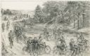
| Date: | 1948 |
|---|---|
| Description: | Pencil drawing depicting a group of men and women bicycling on a dirt road in a rural, wooded area, probably in the 1880's. One man and woman are riding a ... |

| Date: | 1848 |
|---|---|
| Description: | Pen-and-ink on paper. The title of the map is inscribed on the back. The map shows buildings, roads, marshes, wild rice, piles and docks, deep water, and o... |

| Date: | 1840 |
|---|---|
| Description: | Pen-and-ink on paper. Map shows 1840’s homes with owner names, a Native American cemetery, and other points of interest. Relief shown by hachures. Oriented... |

| Date: | 1800 |
|---|---|
| Description: | Ink on tracing cloth. Shows property owners in block 69, between Fourth and Third Street. |

| Date: | 1900 |
|---|---|
| Description: | Pen and pencil on tracing paper. Shows landownership by name, local streets, local businesses, mill pond, creek, and proposed railroad. |

| Date: | 08 24 1899 |
|---|---|
| Description: | Pen-and-ink and color on paper. Also shows probable routes of the French explorers Constant le Marchand de Lignery in 1728 and Louis de la Porte de Louvign... |

| Date: | 06 08 1960 |
|---|---|
| Description: | Blueprint plat of Sunset Hills sub-division. |

| Date: | 1800 |
|---|---|
| Description: | Ink and watercolor on tracing paper. Shows plat of town, local streets, Fond du Lac River, and part of Lake Winnebago. |

| Date: | 1840 |
|---|---|
| Description: | Map shows three Wisconsin territories, Jefferson, Waukesha, and Milwaukee. Map is ink, pencil, and watercolor on paper. Relief shown by hachures. |
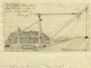
| Date: | 1827 |
|---|---|
| Description: | Increase Lapham's drawing of a rig designed by Mr. Orange Dibble for removing rocks and other large debris from deep canal cuts. |
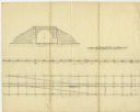
| Date: | 02 15 1830 |
|---|---|
| Description: | Increase Lapham's drawing of a railroad tunnel and railroad tracks. |

| Date: | 1830 |
|---|---|
| Description: | Plat map showing lots and streets. A few lots are marked with names, including: Boyd, Newton, Williams, Baird, Suydam, etc. |
If you didn't find the material you searched for, our Library Reference Staff can help.
Call our reference desk at 608-264-6535 or email us at: