 Filter: Categories of Wisconsin Historical Images
Filter: FORMAT_TYPE of drawings
Filter: Subject of transportation
Filter: County of Milwaukee
Filter: Categories of Wisconsin Historical Images
Filter: FORMAT_TYPE of drawings
Filter: Subject of transportation
Filter: County of Milwaukee
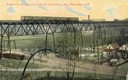
| Date: | 1911 |
|---|---|
| Description: | Elevated view across valley toward a streetcar viaduct on the Waukesha Interurban Line, near Milwaukee. Caption reads: "Street Car Bridge on Waukesha Inter... |
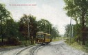
| Date: | 1911 |
|---|---|
| Description: | Colorized view of the railroad curve near Whitefish Bay resort. Caption reads: "The Curve near Whitefish Bay Resort." |
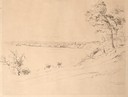
| Date: | 08 1852 |
|---|---|
| Description: | Pencil drawing of a lake shoreline. A few trees frame the arc of the shore and steamboats are visible along the distant shore. |

| Date: | 08 1852 |
|---|---|
| Description: | Pencil drawing of Milwaukee Harbor with large sailboats on the water. In the minimalist depiction the sandy shoreline with short plant growth sweeps aroun... |
| Date: | 1850 |
|---|---|
| Description: | An illustration of the Old North Pier landing on Huron Street, drawn from memory. |
| Date: | |
|---|---|
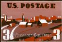
| Description: | Design in shades of red for 3 cent Wisconsin Centennial postage stamp with farming and industry theme. |
| Date: | |
|---|---|
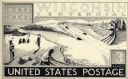
| Description: | Design in black and white for the Wisconsin Centennial 3 cent postage stamp featuring a travel, industry, and agriculture theme. The main design element is... |
| Date: | |
|---|---|
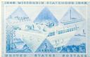
| Description: | Design for Wisconsin Centennial 3 cent postage stamp with an agriculture and industries theme. |
| Date: | 12 13 1947 |
|---|---|
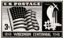
| Description: | Design in blue for Wisconsin Centennial 3 cent postage stamp featuring a badger in a subtle "W" design. |

| Date: | 05 1956 |
|---|---|
| Description: | Perspective drawing of the Sy Dolnick Residence, "Woodwind," designed by John Randal McDonald. |
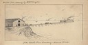
| Date: | |
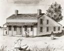
|---|---|
| Description: | Drawing of a two-story building with a roof that slopes down to one story in the back. Two men are on the porch talking, a third is coming off a boat from ... |
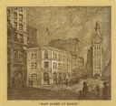
| Date: | |
|---|---|
| Description: | Drawing of North Water Street. Supplementary text reads: "THE STREET OF BEGINNINGS. An Indian trail, leading from the tamarack swamps to LeClair' little ... |
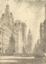
| Date: | 1923 |
|---|---|
| Description: | East Water Street at Mason, looking at the Morris E. Fox & Co. building. |
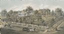
| Date: | 1872 |
|---|---|
| Description: | Lithograph elevated view of the Alexander Mitchell home and gardens seen from the corner of Ninth and Spring Streets. Pedestrians, horse-riders and a horse... |

| Date: | 1844 |
|---|---|
| Description: | An ink on paper, hand-drawn map of Milwaukee County that shows the sectioning of townships, the boundary of the canal grant, roads, streams, lakes, includi... |

| Date: | 1837 |
|---|---|
| Description: | A pen and ink on tracing paper, hand-drawn and colored map the proposed route of the Milwaukee and Rock River Canal, ranging from the Rock River in the wes... |

| Date: | 1855 |
|---|---|
| Description: | Pen-and-ink on paper. Includes certifications signed by surveyor and by "John T. Perkins, by his attorney I.A. Lapham." Inscribed and signed certification ... |

| Date: | 1848 |
|---|---|
| Description: | Pen-and-ink on paper. The title of the map is inscribed on the back. The map shows buildings, roads, marshes, wild rice, piles and docks, deep water, and o... |

| Date: | 1840 |
|---|---|
| Description: | Pen-and-ink on paper. Map shows 1840’s homes with owner names, a Native American cemetery, and other points of interest. Relief shown by hachures. Oriented... |

| Date: | 1800 |
|---|---|
| Description: | Ink on tracing cloth. Shows property owners in block 69, between Fourth and Third Street. |
If you didn't find the material you searched for, our Library Reference Staff can help.
Call our reference desk at 608-264-6535 or email us at: