 Filter: Categories of Wisconsin Historical Images
Filter: FORMAT_TYPE of drawings
Filter: Subject of streets
Filter: Categories of Wisconsin Historical Images
Filter: FORMAT_TYPE of drawings
Filter: Subject of streets
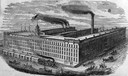
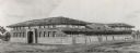
| Date: | 1875 |
|---|---|
| Description: | Drawing of the C.H. & L.J. McCormick Reaper Manufactory (McCormick Reaper Works). The factory was built after the Chicago Fire of 1871 destroyed the origin... |
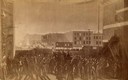
| Date: | 05 04 1886 |
|---|---|
| Description: | Photograph of an artistic rendering of a rally held at Haymarket Square on May 4, 1886, before the explosion of the bomb. Haymarket Square is at the Inters... |

| Date: | 1840 |
|---|---|
| Description: | A hand-drawn plat map of Mineral Point, Wisconsin showing street layout and location of buildings. |
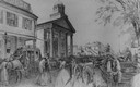
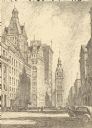
| Date: | 1859 |
|---|---|
| Description: | City Hall in the background of a bustling street, with pedestrians, horses, carriages, and wagons. A stagecoach is parked across the street on the left. |

| Date: | 07 01 1836 |
|---|---|
| Description: | Original plat map of the town of Madison on the four lakes. |
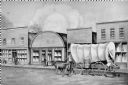
| Date: | 1858 |
|---|---|
| Description: | View on North Water Street, showing the building in which the Bank of Sparta was founded. A man is walking beside a oxen pulling a covered wagon. |
| Date: | 1909 |
|---|---|
| Description: | Architectural drawing. Caption reads: "Market House for the City of Madison". Robert L. Wright, Milwaukee, architect. |
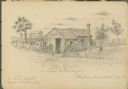
| Date: | 08 28 1885 |
|---|---|
| Description: | Sketch of the shack from which Benedict Goldenberger sold cider vinegar. Possibly on Murray Street. |
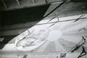
| Date: | 1974 |
|---|---|
| Description: | A view looking down from the Wisconsin State Historical Society building to artwork on the cement of State Street Mall. These paintings on the 800 and 900 ... |
| Date: | 1974 |
|---|---|
| Description: | A view looking down from the Wisconsin State Historical Society building to artwork on the cement of State Street Mall. These paintings on the 800 and 900 ... |
| Date: | |
|---|---|
| Description: | Drawing of North Water Street. Supplementary text reads: "THE STREET OF BEGINNINGS. An Indian trail, leading from the tamarack swamps to LeClair' little ... |

| Date: | 1881 |
|---|---|
| Description: | Ink, watercolor, and pencil on paper. Top of the map reads: "NORTHERN OUTLET MENASHA MEANDER LINES Scale 132ft 1 INCH Var S.E. Survey Completed Spet. 23 18... |
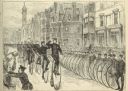
| Date: | 05 30 1881 |
|---|---|
| Description: | Engraving of a sketch by Joseph Pennell showing a parade of League of American Wheelmen bicyclists along Commonwealth Avenue between Dartmouth Street and W... |
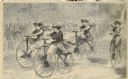
| Date: | 12 1868 |
|---|---|
| Description: | Engraved view of four women racing on bicycles. Spectators in the background are behind a fence. |

| Date: | 1855 |
|---|---|
| Description: | Pen-and-ink on paper. Includes certifications signed by surveyor and by "John T. Perkins, by his attorney I.A. Lapham." Inscribed and signed certification ... |

| Date: | 1848 |
|---|---|
| Description: | Pen-and-ink on paper. The title of the map is inscribed on the back. The map shows buildings, roads, marshes, wild rice, piles and docks, deep water, and o... |

| Date: | 1840 |
|---|---|
| Description: | Pen-and-ink on paper. Map shows 1840’s homes with owner names, a Native American cemetery, and other points of interest. Relief shown by hachures. Oriented... |

| Date: | 1800 |
|---|---|
| Description: | Ink on tracing cloth. Shows property owners in block 69, between Fourth and Third Street. |

| Date: | 1900 |
|---|---|
| Description: | Pen and pencil on tracing paper. Shows landownership by name, local streets, local businesses, mill pond, creek, and proposed railroad. |

| Date: | 06 08 1960 |
|---|---|
| Description: | Blueprint plat of Sunset Hills sub-division. |
If you didn't find the material you searched for, our Library Reference Staff can help.
Call our reference desk at 608-264-6535 or email us at: