Filter: Categories of Wisconsin Historical Images
Filter: FORMAT_TYPE of drawings
Filter: Subject of mounds
Filter: Categories of Wisconsin Historical Images
Filter: FORMAT_TYPE of drawings
Filter: Subject of mounds

| Date: | 1876 |
|---|---|
| Description: | A sketch map of the procession of Indian mounds on the two ridged field sites in Grant County. |

| Date: | 04 12 1912 |
|---|---|
| Description: | Diagram of a bird effigy mound found in Frost's Woods, Blooming Grove Township. |

| Date: | |
|---|---|
| Description: | Map of prehistoric mounds near the Big Kanawha River. |

| Date: | |
|---|---|
| Description: | Ink and watercolor of prehistoric mounds near the mouth of Haigs Creek and the Scioto River. |

| Date: | 1864 |
|---|---|
| Description: | This map is pen and watercolor on paper and shows profile and geological formation of Blue Mound and location of Arnold’s Hotel and Brigham Lead Mines. |

| Date: | 1913 |
|---|---|
| Description: | Ink and watercolor on tracing cloth. Shows parts of Green Lake, Princeton, and Brooklyn townships, Indian mound groups, Green Lake, and other significant b... |

| Date: | 1800 |
|---|---|
| Description: | An ink on paper map for a plan of mounds in Milwaukee county. The map is situated pointing north. |

| Date: | 1800 |
|---|---|
| Description: | This map on two sheets shows a group of ancient mounds near the southeast corner of the city of Beloit and a group of ancient mounds north of Rockton Stati... |

| Date: | |
|---|---|
| Description: | This map is pen-and-ink on tracing paper with a mounted legend and shows the Kickapoo River, Indian mounds, the 1st Fort Crawford, an Indian Agency, the si... |
| Date: | |
|---|---|
| Description: | A sketch of effigy mounds at Myrick Park. There is some scribbled-out writing at the top of the page. |

| Date: | 06 30 1939 |
|---|---|
| Description: | A drawing of a lizard-shaped Indian mound at Hudson Park. |

| Date: | 11 03 1903 |
|---|---|
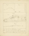
| Description: | A drawing of a group of burial mounds in Linden Valley. Text on back reads: "These mounds lie at the narrow mouth of Linden Valley on the east side of the ... |
If you didn't find the material you searched for, our Library Reference Staff can help.
Call our reference desk at 608-264-6535 or email us at: